

Trax from Zetx: Visual Analysis
Have you ever had to sift through spreadsheets of data looking for that needle in a haystack that will help solve your case? Trax software from Zetx recognizes cell phone data in any format from any provider and uses it to map the cell towers, create visuals of call information, highlight callers' habits, and even autofill search warrants. And it's simple enough that any officer can use it.

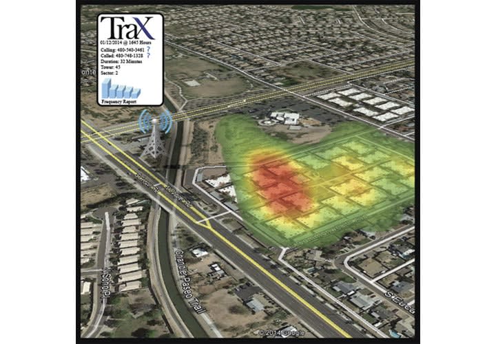
Photo: Zetx
Have you ever had to sift through spreadsheets of data looking for that needle in a haystack that will help solve your case? Trax software from Zetx recognizes cell phone data in any format from any provider and uses it to map the cell towers, create visuals of call information, highlight callers' habits, and even autofill search warrants. And it's simple enough that any officer can use it.
Sy Ray is now the president of Zetx, but he started as a police officer with the Gilbert (Ariz.) Police Department who wanted an easier way to use phone record data in investigations. Through trial and error, he discovered patterns in the data and techniques that worked for him to find useful information, but it was all done manually.
"I figured there must be a way to automate that system so that it visualizes cellular records," says Ray. Determined, he taught himself programming so he could develop Trax.
Because he and his colleagues at Zetx have experience building cases with cell phone data, they understand what tools are most helpful to officers. One major component that makes Trax so useful is that it provides a visual of all of the call information from each tower.
Say a subject travels from Phoenix to Salt Lake City and makes 14 phone calls along the way. "Once you get those records, you pop it in the program and in about 30 seconds it kicks out a KML file, which loads into Google Earth and shows all the towers between Salt Lake and Phoenix that were used, in chronological order," explains Ray. "And it will actually animate the process, taking you on a flying visual tour from tower to tower. And each time it displays a tower it will actually display the call information: who called, how long the call was, etc."
Not content to stop there, Ray developed Trax to communicate not just which tower was used and from which side of the tower the call came, but to calculate how far away from each tower a call might have been made. This can help pinpoint the location of a call, which is often key to solving cases. In a densely populated area, one cell phone might use different cellular towers at different times. Trax uses an algorithm that looks at each tower in conjunction with each neighboring tower to determine the estimated coverage area and displays an overlay on the visual map.
Zetx has also developed a way to create an easily understood visual of callers' habits to pinpoint their location over time and on key dates. "We'll have heat maps that will figure out where people spend most of their time [based on where they're making calls from]," Ray says. "And for specific events like a homicide or robbery, the actual cell tower data can show where the events happened."
Another key component of Trax is how easily investigators can share their reports with everyone who might need to view the data during the course of a court case, without worrying about licensing issues or program compatibility.
"Anybody who has the free version of Google Earth can view the final product," Ray says. "You can burn it to disks for everybody." That means you can send Trax reports to the prosecutor and the defense attorney for discovery. These reports are saved as Google Earth-supported KML files, which are designed to hold large amounts of data in a very compressed file. This makes sending a file as an e-mail attachment simple.
Now Zetx is gearing up to roll out phase 2 of Trax, which will include an app to allow officers to receive real-time notification of a subject's location via GPS. This information can be sent to the phone of any other officer on duty via a dropdown menu to help find a suspect. But this geolocation tool can be used to locate officers as well. "It puts GPS on every officer in the department who has his or her phone on, so it’s a big officer safety tool," says Ray.
For now, Zetx offers visual automated phone data analysis that every member of an agency can use on any device with an Internet connection. "We're trying to package Trax so it's affordable for smaller agencies of around 50 officers or less," says Ray. "It essentially gives those who don't have big resources expert cell phone record analysis abilities on a web-based program."
More Technology
Safariland Solis Rethinks Concealable Duty
What if Level I retention didn’t require a full duty rig? Safariland’s Solis delivers trusted ALS security in a streamlined OWB platform built for administrative and plainclothes professionals who need protection without the bulk.
Read More →
How Patrolfinder Uses Data to Make Streets Safer
Law enforcement agencies have long relied on instinct and routine to optimize patrols. Patrolfinder uses data to help agencies see where officers go — and where they don’t — to improve visibility and maximize coverage.
Read More →
Crime Prevention by Merging Tech with Human Intervention
Elite Interactive Solutions tackles crime prevention with technology and human intervention, working closely with local police to provide insights when a response is needed. The key is to blend the latest in remote video monitoring, artificial intelligence, and a well-trained agent with eyes on the scene.
Read More →

Case Study Details Integration of Body-Worn Cameras with CAD
The Billerica Police Department (Massachusetts) improved transparency and accountability, sharpened evidence management, and reduced manual hours by integrating Axis Communications body-worn cameras with its Computer-Aided Dispatch (CAD) system.
Read More →
ZeroEyes Public Safety Alerts Integrates Samdesk for Real-Time Risk Detection and Awareness
ZeroEyes has integrated Samdesk into its Public Safety Alerts platform to deliver faster, verified intelligence to help organizations understand emerging risks and respond quickly.
Read More →
NJ Police Department Combines Strong Technology & Public Safety Strategy
The Fort Lee Police Department in New Jersey has modernized with Genetec Security Center, including video management, automatic license plate recognition (ALPR), and Clearance digital evidence management.
Read More →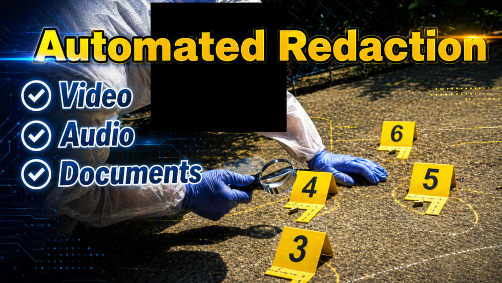
Pimloc & Dynamic Workflow Solutions Partner to Deliver Data Management and Automated Redaction
The joint redaction solution from Pimloc and Dynamic Workflow Solutions helps agencies reduce FOIA response time and compliance risk by automatically redacting faces, license plates, and other sensitive information from digital evidence.
Read More →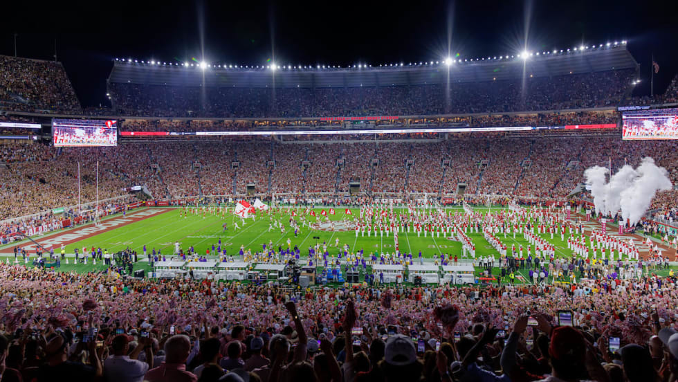
The University of Alabama Rolls Out Couter-Drone Technology
The University of Alabama is using D-Fend Solutions as a counter-drone technology supplier for campus and game-day airspace security. The University integrates D-Fend’s EnforceAir into its Emergency Operations Center (EOC), utilizing a unified command framework to collaborate with local, state, and federal partners during major events.
Read More →
Motorola Solutions Now Part of the Cyber Threat Alliance
Motorola Solutions is now part of the Cyber Threat Alliance, the first formally organized nonprofit group of cybersecurity practitioners that work together in good faith to share threat information and improve global defenses against advanced cyber adversaries.
Read More →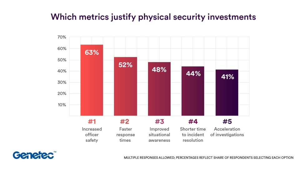
Genetec 2026 State of Physical Security Report Reveals Public Safety Priorities & Challenges
Survey results from Genetec’s 2026 State of Physical Security Report highlight the demand for integrated systems that improve response times and reduce investigative workload. Nearly nine in 10 respondents said they use security data to help keep officers safe.
Read More →