

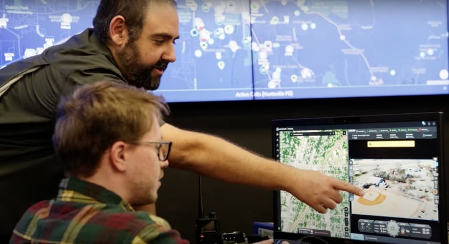
Ohio’s Statewide Drone First Responder Program to Take Flight
Over the next two years, the Ohio DFR Pilot Program will equip municipalities with advanced drone systems, deliver comprehensive training for first responders, and enable FAA-approved Beyond Visual Line of Sight operations.
SkyfireAI will coordinate with CAL Analytics, the Ohio Department of Transportation’s unmanned traffic management software partner, to launch the Ohio Drone First Responder (DFR) Pilot Program.
SkyfireAI
SkyfireAI has been selected by the Ohio Department of Transportation (ODOT) to serve as program manager, in collaboration with CAL Analytics, ODOT’s unmanned traffic management software partner, for the Ohio Drone First Responder (DFR) Pilot Program.
Created under Ohio House Bill 96, this two-year pilot program will evaluate how drones can improve situational awareness, reduce emergency response times, and enhance the safety of first responders across law enforcement, fire, and EMS agencies.
10 Tips for Starting a Drone as First Responder Program
“Ohio’s statewide DFR program isn’t just a first, it’s the blueprint,” said Don Mathis, co-founder and CEO SkyfireAI. “We commend Ohio’s vision in creating the nation’s first statewide DFR program, and we are honored to be entrusted with managing its execution. By unifying policy, training, and technology under one roof, Ohio is making DFR accessible to every community, especially rural departments that could never justify a standalone program. This is how we scale safe autonomy, save minutes, and save lives.”
“Ohio is proving once again that we are the HOME of aviation and at the forefront of aviation innovation,” said State Representative Bernie “Bunyan” Willis, chair of the Ohio House Transportation Committee. “By launching the first statewide Drone First Responder program, we are showing how unmanned aerial systems can enhance public safety, accelerate emergency response, and strengthen our communities. This program is not just about technology—it’s about saving lives and setting the standard for the rest of the nation.”
ODOT’s Leadership in Aviation Innovation
Through its DriveOhio initiative and UAS Center, ODOT has led the nation in advancing advanced aviation and drone integration. Since 2013, ODOT’s UAS Center has managed statewide efforts fostering collaboration between public, private, and academic sectors to push aviation technology forward.
SkyfireAI emphasized that this program reflects ODOT’s leadership and commitment to public safety innovation, noting that Ohio is setting a precedent for other states to follow.
“Ohio has long been a leader in advanced aviation, and this program takes that commitment to the next level,” said Richard Fox, Director of the DriveOhio UAS Center. “By launching the nation’s first statewide Drone First Responder initiative, we are not only giving first responders tools to save lives and protect communities, but also setting a model for how states can safely integrate drone technology at scale.”
SkyfireAI’s Role as Program Manager
As program manager, SkyfireAI will oversee every phase of the pilot, from coordinating with vendors and municipalities to select and install rooftop drone systems, to ensuring compliance with FAA regulations, to training operators on best practices for DFR deployment.
SkyfireAI said it brings extensive experience to this role, having managed and operated municipal DFR programs in several cities across the country and spearheaded medical drone delivery pilot programs and disaster response initiatives with CVS Health. The company’s expertise spans UAS integration, FAA waiver navigation, UAS traffic management (UTM), and large-scale public safety training.
In addition, SkyfireAI said its advancements in artificial intelligence and automated data analysis provide a pathway for scaling the program even further. This program paves the path for BVLOS-enabled autonomy, multi-ship ops, even and true 24/7 coverage where single-agency economics don’t work.
The integration of AI could support rapid damage assessment, automated detection of hazards, and more efficient resource deployment — capabilities that will help expand the reach and impact of DFR programs statewide and nationally.
CAL Analytics' Role as Lead Integrator
As a technical integrator for this initiative, CAL Analytics will collaborate with drone manufacturers and first responders across Ohio to connect them to statewide services that enable safe, coordinated drone operations. This includes the development of the nation’s first statewide Uncrewed Traffic Management (UTM) system, designed to strategically deconflict drone activity and ensure operational safety. A network of airspace monitoring and detection sensors will also provide enhanced situational awareness for DFR operators by identifying and tracking nearby aircraft.
Program Highlights
Over the next two years, the Ohio DFR Pilot Program will equip municipalities with advanced drone systems, deliver comprehensive training for first responders, and enable FAA-approved Beyond Visual Line of Sight operations. By standardizing statewide procedures, collecting and analyzing performance data, and engaging communities through transparent outreach, the program will demonstrate how drones can become a trusted, life-saving tool for public safety agencies across Ohio and beyond.
Learn More: Launching Police Drone Programs
More Technology

Cellebrite Expands Exclusive SkySafe Partnership to Deliver Immediate Drone Detection and Airspace Intelligence for Digital Investigations at Scale
By integrating SkySafe's drone detection and airspace intelligence with Cellebrite's platform, agencies can connect real-time and historical UAV flight data with mobile forensic evidence, all in one place.
Read More →
New DroneShield Report Reveals Serious Gaps in Airport, Critical Infrastructure Counter-Drone Security
Survey results, as part of “Airspace Under Pressure: A Global Assessment of Counter-UAS Readiness Across Airports and Critical Infrastructure,” indicate that 60% of organizations say they lack legal authority to act against unauthorized drones.
Read More →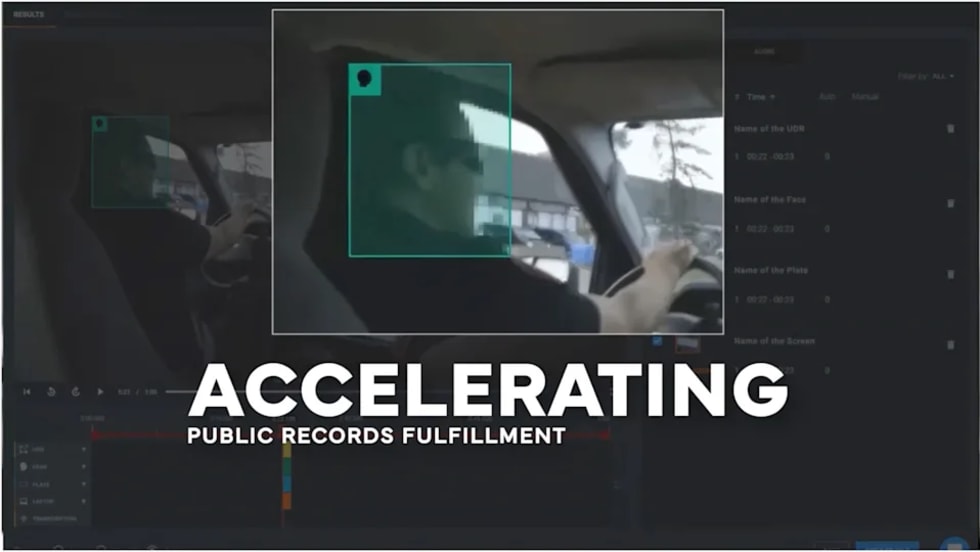
CHP to Accelerate Evidence Redaction & Public Records Fulfillment Through Veritone Redact
With Veritone Redact, the California Highway Patrol can redact video, audio, and image-based evidence, reducing time spent on evidence preparation and public record requests.
Read More →

Echodyne Expands Public Safety Radar Applications Through Partnership with Axon
Echodyne has partnered with Axon to support safer and more scalable drone operations across law enforcement, homeland security, and Drone as First Responder programs globally.
Read More →
Miami Police Department Deploys Airwayz’s Overwatch Platform During FIFA World Cup Events
The deployment of Airwayz’s Overwatch airspace management platform during the FIFA World Cup demonstrates the future of airspace infrastructure for managing, securing, and coordinating complex urban airspace environments.
Read More →
How Patrolfinder Uses Data to Make Streets Safer
Law enforcement agencies have long relied on instinct and routine to optimize patrols. Patrolfinder uses data to help agencies see where officers go — and where they don’t — to improve visibility and maximize coverage.
Read More →
Crime Prevention by Merging Tech with Human Intervention
Elite Interactive Solutions tackles crime prevention with technology and human intervention, working closely with local police to provide insights when a response is needed. The key is to blend the latest in remote video monitoring, artificial intelligence, and a well-trained agent with eyes on the scene.
Read More →
Case Study Details Integration of Body-Worn Cameras with CAD
The Billerica Police Department (Massachusetts) improved transparency and accountability, sharpened evidence management, and reduced manual hours by integrating Axis Communications body-worn cameras with its Computer-Aided Dispatch (CAD) system.
Read More →
ZeroEyes Public Safety Alerts Integrates Samdesk for Real-Time Risk Detection and Awareness
ZeroEyes has integrated Samdesk into its Public Safety Alerts platform to deliver faster, verified intelligence to help organizations understand emerging risks and respond quickly.
Read More →
NJ Police Department Combines Strong Technology & Public Safety Strategy
The Fort Lee Police Department in New Jersey has modernized with Genetec Security Center, including video management, automatic license plate recognition (ALPR), and Clearance digital evidence management.
Read More →