



FLIR and DJI Announce Collaboration for Commercial Drones with Thermal Imaging
FLIR Systems, Inc. today announced a new technology collaboration with established drone industry company DJI Innovations. Under the strategic arrangement, the companies also announced plans to develop their first joint product.

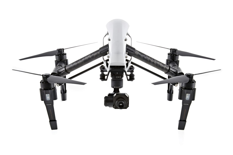
The Zenmuse XT will be available in early 2016 at both DJI and FLIR dealers. (Photo: FLIR)
FLIR Systems, Inc. today announced a new technology collaboration with established drone industry company DJI Innovations. Under the strategic arrangement, the companies also announced plans to develop their first joint product, the DJI Zenmuse XT stabilized camera featuring FLIR's thermal imaging technology for DJI's Inspire 1 and Matrice aerial platforms.
Combining DJI's Zenmuse stabilized micro-gimbal technology, which has become a common platform for demanding aerial cinematography, with FLIR's popular Tau 2 thermal imaging camera core, the Zenmuse XT will expand the possibilities for commercial drone operators and infrastructure inspectors. Using FLIR thermal imaging on small drones brings new capabilities to dozens of commercial applications, including search and rescue, firefighting, agriculture, wildlife protection, and the inspection of energy infrastructure, bridges, and buildings, according to FLIR.
The addition of thermal imaging provides users the ability to see in complete darkness, measure temperature remotely, and see through obscurants like smoke, dust, and light fog, according to the company. Zenmuse XT users will have the ability to see minute temperature variances – normally invisible to the naked eye – that can signify potential problems in buildings, detect the presence of people or animals, and monitor the health of mechanical and electrical equipment remotely. Its integration with DJI's Lightbridge live video downlink system and the DJI GO app will also give drone operators real-time control and recording during flight.
"FLIR and DJI today support many of the same commercial applications," said Andy Teich, President and CEO of FLIR. "FLIR is thrilled to work with DJI to deliver these customers a plug-and-play thermal imaging solution for DJI's established ecosystem of unmanned aircraft and related apps while expanding our collective opportunities in the rapidly-growing commercial drone market."
DJI's Inspire 1 and Matrice airframes provide aerial cinematography and development platforms. The same attributes that are designed to set these airframes apart for capturing stunning aerial video – stable flight performance, predictable flight execution, and seamless integration with the popular DJI Go app – also make them ideal thermal imaging platforms, the company says.
"DJI's collaboration with FLIR in thermal imaging signals our intent to innovate in sectors where technology can be a game-changer," said DJI CEO Frank Wang. "The result will be joint, best-in-class solutions that are intuitive and easy to use."
The Zenmuse XT will be available in early 2016 at both DJI and FLIR dealers. You can visit https://www.dji.com/product/zenmuse-xt to learn more.
FLIR Systems, Inc. is known for its design, manufacture, and marketing of sensor systems that enhance perception and awareness. FLIR's advanced thermal imaging and threat detection systems are used for a wide variety of imaging, thermography, and security applications, including airborne and ground-based surveillance, condition monitoring, research and development, manufacturing process control, search and rescue, drug interdiction, navigation, transportation safety, border and maritime patrol, environmental monitoring, and chemical, biological, radiological, nuclear, and explosives (CBRNE) detection. For more information, go to FLIR's website at www.FLIR.com.
More Technology

A police agency's guide to data-driven fleet management
Costs are rising and the public expects more transparency into how their tax dollars are spent. This e-book shows how police agencies can use fleet data to take control of fleet expenses while improving officer safety and demonstrating fiscal responsibility to the communities they serve.
Read More →
AI and analytics for law enforcement: Turning data into insights
Law enforcement agencies are managing more video, sensor data and digital evidence than ever before. Discover how AI and analytics can help turn that data into actionable insights that strengthen situational awareness, accelerate investigations and support more informed decisions.
Read More →
Vasco Electronics Adds Automatic Language Detection to Vasco Translator Q1
Vasco Electronics’ software update introduces hands-free language switching and expanded offline translation across 45 language pairs, empowering law enforcement, healthcare, and front-office enterprise teams
Read More →

North Miami Police Department Deploys Mark43
The North Miami Police Department has deployed Mark43 as part of its Five-Year Strategic Plan that represents its collective vision and goals for a more proactive police department, anchored by a core commitment to leveraging modern technology to enhance efficiency and public safety.
Read More →
Cellebrite Genesis for Enterprise Now Generally Available
Made available to the public sector in June, Cellebrite Genesis is serving a growing mix of national, regional, and local agencies worldwide, including some of the largest regional and metropolitan police departments. It is now available for enterprise organizations.
Read More →
2026 Vision FirstNet Users Summit to Host Emerging Leaders Training on Grassroots Advocacy for Public Safety
“Emerging Leaders Training: Understanding the Importance of Grassroots Advocacy for Public Safety," a session during the 2026 Vision FirstNet Users Summit, will offer a roadmap for unified advocacy at the federal level.
Read More →
Motorola Solutions Completes Acquisition of D-Fend Solutions
Motorola Solutions has acquired D-Fend Solutions, an industry leader in counter-drone technology. This deal provides public safety and enterprise customers with access to advanced counter-unmanned aerial systems.
Read More →
ZeroEyes, Advantech & Camden Police Partner to Bring AI Gun Detection Technology to Delaware School District
ZeroEyes has partnered with Advantech and the Camden Police Department to deploy ZeroEyes’ AI gun detection and intelligent situational awareness platform at Delaware’s Caesar Rodney School District (CRSD).
Read More →
Leonardo U.S. Cyber & Security Solutions Introduces SignalTrace, the Next Evolution in Electronic Signature Detection Technology
SignalTrace reflects years of product refinement and a clearer expression of the technology’s purpose of recognizing and correlating electronic signatures in publicly broadcast wireless signals to reveal patterns, relationships, and trends that might otherwise go undetected.
Read More →
Pimloc Launches Secure File Sharing to Streamline Release of Redacted Video
Pimloc’s Secure File Sharing lets organizations deliver redacted video, audio, and documents through expiring, passcode-protected links, accelerating delivery while reducing security, compliance, and chain-of-custody risks.
Read More →