POLICE Logo
MenuMENU
SearchSEARCH

Carlson Wireless Announces Trailblazer Point-to-Point Solution

The Trailblazer 5.9 is a point-to-point solution designed for back-hauling two-way radio communications or Dedicated Short Range Communications (DSRC) projects because of its extraordinary resistance to interference and weather. The Trailblazer itself provides ultra-low fixed latency and rugged reliability, according to the company.

August 26, 2011
Carlson Wireless Announces Trailblazer Point-to-Point Solution

Photo: Carlson Wireless.

2 min to read


Carlson Wireless introduced the Trailblazer 5.9 earlier this month at the APCO convention in Philadelphia several days after receiving FCC certification. The product, one of the first of its kind certified to operate in the 5.9 GHz frequency band, was custom-designed for departments of transportation.

The Trailblazer 5.9 is a point-to-point solution designed for back-hauling two-way radio communications or Dedicated Short Range Communications (DSRC) projects because of its extraordinary resistance to interference and weather. The Trailblazer itself provides ultra-low fixed latency and rugged reliability, according to the company.

Ad Loading...

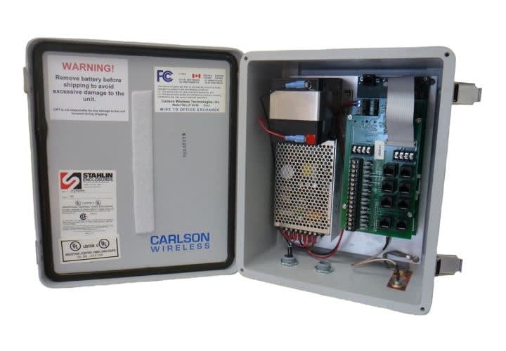
Carlson developed the 5.9 after being approached by a transportation customer who expressed a need that had yet to be met by any other product. The 5.9 offers a unique blend of video, telemetry, Ethernet, voice, and data. This varied arsenal of capabilities heightens efficiency when reporting road closures, issue traffic alerts, emergency warnings for short-range vehicles, two-way radio backhaul, leaded line replacement, POTS line wireless transport and Ethernet transport.

The 5.9 GHz frequency band offers a full 70-megahertz of spectrum set aside by the FCC especially for Intelligent Transportation Systems (ITS). This particular band is ideal for both the public safety and departments of transportation industries because it can support the high data rates that traffic applications require.

The 5.9 offers a plug-and-play setup of a fully integrated device. It is solar powerable and comes in a sturdy weatherproof enclosure for roadside deployment.

The FCC divides the 5.9 GHz band into seven 10-megahertz channels and issues non-exclusive licenses to government and public safety entities to operate on the band. Applicants can file electronically with the FCC using FCC Form 601.

Licensees need only register their sites, channels and other relevant data on a Universal Licensing System, coordinating with the Telecommunications and Information Administration (NTIA) for proximity to government radar sites.

Ad Loading...

More Technology

over shoulder view of woman holding phone and making an emergency call and sharing video
TechnologyDecember 11, 2025

Motorola Solutions and Google Let Android Users Share Live Video with 911 in Seconds

Motorola Solutions’ 911 command center software now integrates with Google’s Android Emergency Live Video, so callers can let first responders see their emergency with a single click.

Read More →
thumbnail for video series POLCIE From the Show Floor, white headline for Versaterm, all set against a black background with police light bar.
Technologyby Wayne ParhamDecember 10, 2025

From the Show Floor: Versaterm

Learn more about Versaterm as POLICE visits with Rohan Galloway-Dawkins, chief product officer, to explore the company’s focus on a purpose-built platform for public safety.

Read More →
Thumbnail for POLICE video From the Show Floor: Motorola Solutions
Technologyby Wayne ParhamDecember 4, 2025

From the Show Floor: Motorola Solutions

In this video, learn about the Motorola Solutions ecosystem and how it provides tools that enhance the efficiency and safety of police officers. You’ll hear about the APX NEXT radio and SVX system, Assisted Narrative, and more.

Read More →
Ad Loading...
Black and purple background with logos for Veritone and Armada
TechnologyDecember 4, 2025

Veritone & Armada Partner to Deliver Mission-Critical Edge Intelligence for Public Safety

Veritone and Armada will deliver a fully integrated edge-to-enterprise data fabric, capable of ingesting high-volume audio, video, drone, and sensor streams in the field and transforming them into actionable intelligence.

Read More →
Closeup photo of man's hand holding a phone with an app displayed and out of focus police cars in the background
TechnologyDecember 3, 2025

Genetec Launches Cloudrunner Mobile App for Real-Time Vehicle Investigations in the Field

Genetec’s new Cloudrunner Mobile app extends Cloudrunner capabilities to the field, giving law enforcement and security professionals faster access to data and alerts wherever they are.

Read More →
SponsoredNovember 3, 2025

Learning How to Manage Your Fleet?

Watch this tutorial on how fleet management platforms work. You’ll see how easily you can integrate fleet telematics, dash cameras, and asset management in a single pane of glass and manage your fleet more effectively.

Read More →
Ad Loading...
thumbnail from video series From the Show Floor, headline features Semtech.
Technologyby Wayne ParhamOctober 31, 2025

From the Show Floor: Semtech

Learn about the latest ruggedized routers designed for public safety vehicles as POLICE visits with Greg Hill of Semtech. These routers are equipped with the latest 5G technology.

Read More →
patrolfinder - reducing crime thumbnail
SponsoredOctober 27, 2025

How One Police Department Cut Crime by 46% with Smarter Patrol Management

Discover how one police department cut crime nearly in half using smarter patrol data. This whitepaper breaks down the real-world strategy behind a 46% drop in vehicle thefts, improved officer safety, and stronger community visibility.

Read More →
Photo of three computer screens displaying software soluitions in a trade show booth.
TechnologyOctober 26, 2025

Genetec Showcases Its Latest Public Safety Innovations at IACP 2025

Genetec demonstrated its Cloudrunner, Citigraf, and Clearance during IACP 2025 to show how they can provide law enforcement with a unified situational awareness to make cities safer.

Read More →
Ad Loading...
Analysts reviewing geospatial data on multiple computer screens in a monitoring center
PatrolOctober 14, 2025

Ohio’s Statewide Drone First Responder Program to Take Flight

Over the next two years, the Ohio DFR Pilot Program will equip municipalities with advanced drone systems, deliver comprehensive training for first responders, and enable FAA-approved Beyond Visual Line of Sight operations.

Read More →