



South Dakota Officials Locate Sunken Pickup Using Underwater Sonar
The sonar equipment paints a picture of the riverway bottom and allows for identification of objects without ever getting into the water.

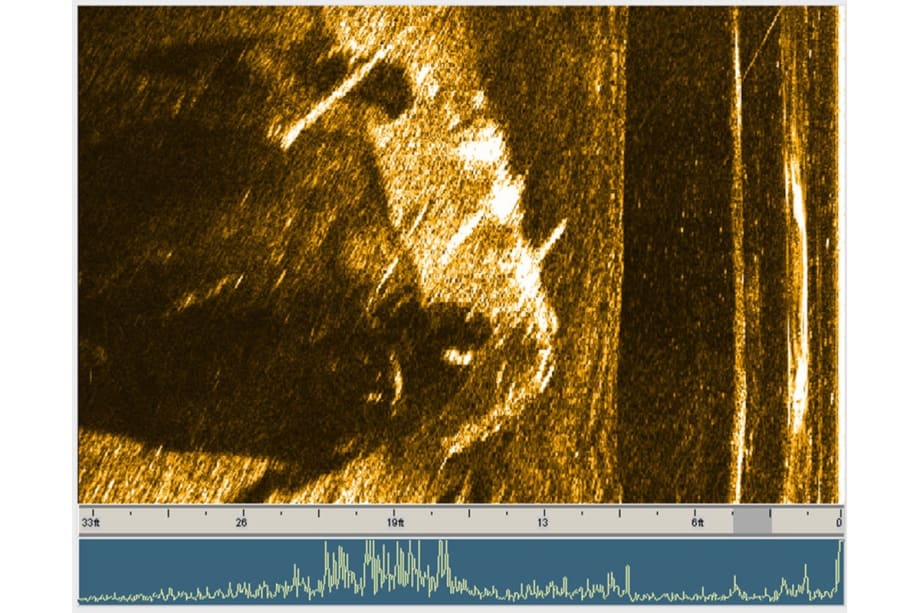
JW Fishers side scan sonar image of pickup truck at bottom of James River in South Dakota.
The James River is a tributary of the Missouri River. It is roughly 710 miles long and spans over 20,000 square miles of North Dakota and South Dakota with more than 70% of the river’s drainage occurring in South Dakota. River conditions during normal years include both still-water and flooding on both the James River and its tributaries. Water easily breaches the low banks, and these floods tend to cover a significant portion of the floodplain. When the river is still, water quality drops and it becomes quite difficult to see more than a few feet underwater.
The Beadle County (SD) Office of Emergency Management (OEM) is responsible for preparing the county for possible disasters. This includes disaster preparation, response, recovery, and mitigation. The office is Beadle County’s liaison to the State of South Dakota’s Office of Emergency Management.
One tool in their possession is a JW Fishers’ side scan sonar system. This system is invaluable for locating downing victims, missing evidence, dumped cars, or ships lost underwater. It becomes especially useful when waters are murky or turbid. The sonar equipment paints a picture of the riverway bottom and allows for identification of objects without ever getting into the water. This is not only easier, dramatically increases team safety.
Tom Moeding, Beadle County’s Emergency Management Director, experienced this first hand. “We used our JW Fishers side scan sonar to pinpoint the location of a 2014 Dodge pickup that was driven into the James River, our local river here in Huron, SD.” The driver behind the wheel ran the vehicle into the river during the middle of the night, but could not remember the exact location. After scouring the shoreline, tire tracks were seen going into the river and the dive team was deployed to find the vehicle. “You can see the pickup was found and its orientation was clearly shown to be on its side. Initially we used a smaller side scan to approximate the location, but the object was just shown as a blob on the screen and not a clear image of the pickup.”
As the old saying goes, practice makes perfect. Tom and his team tried again, “this time the towfish was kept near the surface so as to not ram the pickup truck and cause damage like the last time it was used to locate a garbage truck with two deceased individuals in it in the same river just north of Mitchel SD.
Once the pickup was identified, Dive Team members deployed a J-hook from a Zodiac boat to snag the truck. The hook lodged in a solid area after several attempts and Lincoln Auto Salvage was able to pull it to shore. Beadle Country’s OEM knows first-hand that Fishers’ sonar systems are the right tool for the job, and we are proud to be part of their team!
For more information about JW Fishers' products, please send an email to info@jwfishers.com, visit www.jwfishers.com or call toll free at (800)822-4744.
More Technology

A police agency's guide to data-driven fleet management
Costs are rising and the public expects more transparency into how their tax dollars are spent. This e-book shows how police agencies can use fleet data to take control of fleet expenses while improving officer safety and demonstrating fiscal responsibility to the communities they serve.
Read More →
AI and analytics for law enforcement: Turning data into insights
Law enforcement agencies are managing more video, sensor data and digital evidence than ever before. Discover how AI and analytics can help turn that data into actionable insights that strengthen situational awareness, accelerate investigations and support more informed decisions.
Read More →
Vasco Electronics Adds Automatic Language Detection to Vasco Translator Q1
Vasco Electronics’ software update introduces hands-free language switching and expanded offline translation across 45 language pairs, empowering law enforcement, healthcare, and front-office enterprise teams
Read More →

North Miami Police Department Deploys Mark43
The North Miami Police Department has deployed Mark43 as part of its Five-Year Strategic Plan that represents its collective vision and goals for a more proactive police department, anchored by a core commitment to leveraging modern technology to enhance efficiency and public safety.
Read More →
Cellebrite Genesis for Enterprise Now Generally Available
Made available to the public sector in June, Cellebrite Genesis is serving a growing mix of national, regional, and local agencies worldwide, including some of the largest regional and metropolitan police departments. It is now available for enterprise organizations.
Read More →
2026 Vision FirstNet Users Summit to Host Emerging Leaders Training on Grassroots Advocacy for Public Safety
“Emerging Leaders Training: Understanding the Importance of Grassroots Advocacy for Public Safety," a session during the 2026 Vision FirstNet Users Summit, will offer a roadmap for unified advocacy at the federal level.
Read More →
Motorola Solutions Completes Acquisition of D-Fend Solutions
Motorola Solutions has acquired D-Fend Solutions, an industry leader in counter-drone technology. This deal provides public safety and enterprise customers with access to advanced counter-unmanned aerial systems.
Read More →
ZeroEyes, Advantech & Camden Police Partner to Bring AI Gun Detection Technology to Delaware School District
ZeroEyes has partnered with Advantech and the Camden Police Department to deploy ZeroEyes’ AI gun detection and intelligent situational awareness platform at Delaware’s Caesar Rodney School District (CRSD).
Read More →
Leonardo U.S. Cyber & Security Solutions Introduces SignalTrace, the Next Evolution in Electronic Signature Detection Technology
SignalTrace reflects years of product refinement and a clearer expression of the technology’s purpose of recognizing and correlating electronic signatures in publicly broadcast wireless signals to reveal patterns, relationships, and trends that might otherwise go undetected.
Read More →
Pimloc Launches Secure File Sharing to Streamline Release of Redacted Video
Pimloc’s Secure File Sharing lets organizations deliver redacted video, audio, and documents through expiring, passcode-protected links, accelerating delivery while reducing security, compliance, and chain-of-custody risks.
Read More →