



Michigan State Police to Use Aeryon SkyRanger UAS Statewide
Based on successful public safety scenario trials and training officers to operate the Aeryon SkyRanger, the Michigan State Police has announced plans to roll out its UAS program statewide.

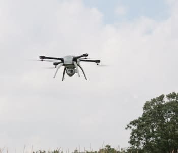
Photo: Aeryon Labs
Aeryon Labs Inc. has announced that the Michigan State Police (MSP) has chosen to standardize its state-wide UAS deployment with the Aeryon SkyRanger, small Unmanned Aerial System (sUAS).
The MSP, a full-service police agency, is currently operating under a Federal Aviation Administration (FAA) training certificate of authorization (COA) to train officers in a number of public safety scenarios to prepare for the state-wide roll out. The goal of the UAS program is to enable officers to operate the Aeryon SkyRanger in applications such as critical incident and natural disaster response, search and rescue, traffic accident reconstruction, as well as scene photography.
"After the success of the UAS training scenarios, we look forward to receiving the operational COA for the entire state" explains F/Lt. Chris Bush, Commander Field Support and Aviation Section, Michigan State Police Special Operations Division. "Our emergency response and investigation teams are anticipating the benefits of using the Aeryon SkyRanger in the field."
Aeryon sUAS enable the immediate, safe, and reliable capture of high quality aerial imagery and data – faster, more accurately, and more cost-effectively than manned aircraft or traditional ground-based methods for collecting information and evidence.
"For the Michigan State Police agency to provide operational UAS capabilities for 83 counties is a significant deployment, especially with training operators who might not have previous experience flying unmanned systems," commented Aeryon Labs President & CEO, Dave Kroetsch. "We know that the Aeryon SkyRanger's easy-to-use interface will help speed up the roll out process and ensure that first responders can gain critical field data quickly and accurately."
The Aeryon SkyRanger will be showcased at the IACP 2014 Conference, Aeryon Labs Booth# 308, October 26-28, 2014 at the Orange County Convention Center in Orlando, Fla..
Aeryon Labs is the premier manufacturer of small Unmanned Aerial Systems (sUAS) which are at the center of major world events and international media stories. The company is the trusted partner of civil and military customers, resellers, and other commercial business partners around the globe. Aeryon Labs is a Canadian Controlled Private Company with headquarters in Waterloo, Ontario, Canada. Field-tested and mission-proven, Aeryon sUAS set the standard for immediate aerial intelligence gathering by anyone, anywhere, anytime, for a wide range of military, public safety and commercial applications.
More Technology

A police agency's guide to data-driven fleet management
Costs are rising and the public expects more transparency into how their tax dollars are spent. This e-book shows how police agencies can use fleet data to take control of fleet expenses while improving officer safety and demonstrating fiscal responsibility to the communities they serve.
Read More →
AI and analytics for law enforcement: Turning data into insights
Law enforcement agencies are managing more video, sensor data and digital evidence than ever before. Discover how AI and analytics can help turn that data into actionable insights that strengthen situational awareness, accelerate investigations and support more informed decisions.
Read More →
Vasco Electronics Adds Automatic Language Detection to Vasco Translator Q1
Vasco Electronics’ software update introduces hands-free language switching and expanded offline translation across 45 language pairs, empowering law enforcement, healthcare, and front-office enterprise teams
Read More →

North Miami Police Department Deploys Mark43
The North Miami Police Department has deployed Mark43 as part of its Five-Year Strategic Plan that represents its collective vision and goals for a more proactive police department, anchored by a core commitment to leveraging modern technology to enhance efficiency and public safety.
Read More →
Cellebrite Genesis for Enterprise Now Generally Available
Made available to the public sector in June, Cellebrite Genesis is serving a growing mix of national, regional, and local agencies worldwide, including some of the largest regional and metropolitan police departments. It is now available for enterprise organizations.
Read More →
2026 Vision FirstNet Users Summit to Host Emerging Leaders Training on Grassroots Advocacy for Public Safety
“Emerging Leaders Training: Understanding the Importance of Grassroots Advocacy for Public Safety," a session during the 2026 Vision FirstNet Users Summit, will offer a roadmap for unified advocacy at the federal level.
Read More →
Motorola Solutions Completes Acquisition of D-Fend Solutions
Motorola Solutions has acquired D-Fend Solutions, an industry leader in counter-drone technology. This deal provides public safety and enterprise customers with access to advanced counter-unmanned aerial systems.
Read More →
ZeroEyes, Advantech & Camden Police Partner to Bring AI Gun Detection Technology to Delaware School District
ZeroEyes has partnered with Advantech and the Camden Police Department to deploy ZeroEyes’ AI gun detection and intelligent situational awareness platform at Delaware’s Caesar Rodney School District (CRSD).
Read More →
Leonardo U.S. Cyber & Security Solutions Introduces SignalTrace, the Next Evolution in Electronic Signature Detection Technology
SignalTrace reflects years of product refinement and a clearer expression of the technology’s purpose of recognizing and correlating electronic signatures in publicly broadcast wireless signals to reveal patterns, relationships, and trends that might otherwise go undetected.
Read More →
Pimloc Launches Secure File Sharing to Streamline Release of Redacted Video
Pimloc’s Secure File Sharing lets organizations deliver redacted video, audio, and documents through expiring, passcode-protected links, accelerating delivery while reducing security, compliance, and chain-of-custody risks.
Read More →