



JW Fishers' Side Scan Sonar Adds Clarity to Underwater Searches
Side Scan SONAR devices allow images of the ocean floor to be viewed as if one is looking through a window. It "removes the water" to provide the operator with a bird's-eye view of their target.

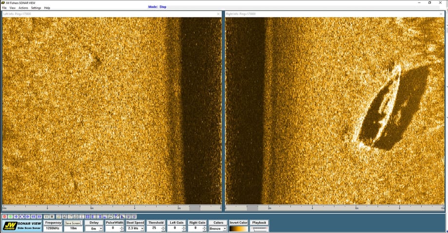
JW Fishers Side Scan Sonar image of boat under water. Photo: JW Fishers
"Memories have huge staying power, but like dreams, they thrive in the dark, surviving for decades in the deep waters of our minds like shipwrecks on the sea bed." — J.G. Ballard
Along with each ship, aircraft, precious object, and priceless heirloom lost in our planet's vast bodies of water, so too sink countless memories, hopes, and occasionally even lives. How do we find these lost memories that are preserved for many years in the dark depths? What tools exist to aid in the search, and can technology help us find these relics? JW Fishers Mfg. has Side Scan SONAR systems to find what's been lost in the depths.
SONAR systems, like many advanced technologies, were at first developed mostly for military applications. The technology has since, however, become very helpful in underwater exploration. Scientists use SONAR to map the seafloor, scan reefs, and measure water depths. Police and Dive Rescue teams use SONAR to find missing persons and evidence while treasure hunters use it to locate shipwrecks and other valuable objects.
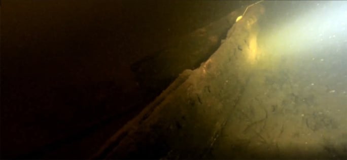
Image of boat under water. Photo: JW Fishers
Side Scan SONAR devices allow images of the ocean floor to be viewed as if one is looking through a window. It "removes the water" to provide the operator with a bird's-eye view of their target. By using computer mapping software, SONAR echoes or "soundings" are converted into colored waterfall images. There are two different types of SONAR. Active SONAR can measure an object's distance. It transmits a sound wave called a ping. This wave bounces off of the object and back to the receiver, called a transducer. The distance to the object is measured by how long it takes for the ping to travel to the object and back to the transducer. Similarly, passive SONAR simply "listens" for sound waves while not producing any of its own.
The Fulton County (GA) Sheriff's Office is a proud owner of JW Fisher's Side Scan technology, and the agency maintains a highly capable team of Side Scan operators and underwater search experts. Not long ago, Sergeants Robert Stemmler and Christopher House came across a suspicious target on a training exercise. "We thought it best to be checked out," said a member of the dive team. Saratoga County's Mike Rogan accompanied Fulton County to check out the area. "It looked like just a boat that came off a dock and went down a long time ago," Rogan said. The old boat was about 4' by 12' and served as a "pretty cool target," according to Rogan. Most of all, JW Fishers says it displayed how truly capable this system is and how clearly a boat can be seen on the system's display.
Fulton County is becoming very proficient with its SONAR system and members of the team were able to drop a marker within 20 feet of the downed vessel. Rogan added, "I took a compass heading and swam right into it." Also of note was challenging water visibility that the team described as "awful," but the Side Scan SONAR helped alleviate all concerns by removing water quality from the equation.
A few of the many other search teams using JWF's side scan systems are South Survey and Mapping Company in China, the Beadle County Office of Emergency Management in South Dakota, The Specialist Group in the United Kingdom, the Suffolk County Sheriffs Marine Unit in New York, Union Fire Company in Pennsylvania, North Carolina Department of Transportation, the US Navy's Explosive Ordinance Disposal (EOD) Technology Division, and the Guangdong Construction Engineering in China.
For more information about JW Fishers' complete line of underwater search equipment, visit www.jwfishers.com.
More Technology

A police agency's guide to data-driven fleet management
Costs are rising and the public expects more transparency into how their tax dollars are spent. This e-book shows how police agencies can use fleet data to take control of fleet expenses while improving officer safety and demonstrating fiscal responsibility to the communities they serve.
Read More →
AI and analytics for law enforcement: Turning data into insights
Law enforcement agencies are managing more video, sensor data and digital evidence than ever before. Discover how AI and analytics can help turn that data into actionable insights that strengthen situational awareness, accelerate investigations and support more informed decisions.
Read More →
Vasco Electronics Adds Automatic Language Detection to Vasco Translator Q1
Vasco Electronics’ software update introduces hands-free language switching and expanded offline translation across 45 language pairs, empowering law enforcement, healthcare, and front-office enterprise teams
Read More →

North Miami Police Department Deploys Mark43
The North Miami Police Department has deployed Mark43 as part of its Five-Year Strategic Plan that represents its collective vision and goals for a more proactive police department, anchored by a core commitment to leveraging modern technology to enhance efficiency and public safety.
Read More →
Cellebrite Genesis for Enterprise Now Generally Available
Made available to the public sector in June, Cellebrite Genesis is serving a growing mix of national, regional, and local agencies worldwide, including some of the largest regional and metropolitan police departments. It is now available for enterprise organizations.
Read More →
2026 Vision FirstNet Users Summit to Host Emerging Leaders Training on Grassroots Advocacy for Public Safety
“Emerging Leaders Training: Understanding the Importance of Grassroots Advocacy for Public Safety," a session during the 2026 Vision FirstNet Users Summit, will offer a roadmap for unified advocacy at the federal level.
Read More →
Motorola Solutions Completes Acquisition of D-Fend Solutions
Motorola Solutions has acquired D-Fend Solutions, an industry leader in counter-drone technology. This deal provides public safety and enterprise customers with access to advanced counter-unmanned aerial systems.
Read More →
ZeroEyes, Advantech & Camden Police Partner to Bring AI Gun Detection Technology to Delaware School District
ZeroEyes has partnered with Advantech and the Camden Police Department to deploy ZeroEyes’ AI gun detection and intelligent situational awareness platform at Delaware’s Caesar Rodney School District (CRSD).
Read More →
Leonardo U.S. Cyber & Security Solutions Introduces SignalTrace, the Next Evolution in Electronic Signature Detection Technology
SignalTrace reflects years of product refinement and a clearer expression of the technology’s purpose of recognizing and correlating electronic signatures in publicly broadcast wireless signals to reveal patterns, relationships, and trends that might otherwise go undetected.
Read More →
Pimloc Launches Secure File Sharing to Streamline Release of Redacted Video
Pimloc’s Secure File Sharing lets organizations deliver redacted video, audio, and documents through expiring, passcode-protected links, accelerating delivery while reducing security, compliance, and chain-of-custody risks.
Read More →