

Cape Works with FAA for Approval of First Beyond Visual Line of Sight Provision for Police Drone Program
The precedent-setting BVLOS provision is a major regulatory win for the entire U.S. drone industry. It will not only lay the groundwork for other public safety agencies, but also open the door for other industries to benefit from their successes.
Cape, a leading cloud platform for drone telepresence and data management, today announced the Federal Aviation Administration (FAA) has granted the first-ever Certificate of Authorization (COA) with a provision for Beyond Visual Line of Sight (BVLOS) for a public safety organization. Cape worked closely with the FAA, and in partnership with the Chula Vista (CA) Police Department and Skyfire Consulting, to finalize the COA, which will open the doors for future drone integration across industries.
The precedent-setting BVLOS provision is a major regulatory win for the entire U.S. drone industry. It will not only lay the groundwork for other public safety agencies, but also open the door for other industries to benefit from their successes. For these agencies, securing a COA that includes a BVLOS provision vastly increases the total allowed area that drones can cover, maximizing the impact of their drone programs. Highly-influential in securing the approval were the capabilities and critical safeguards built into the Cape Aerial Telepresence platform, including the ability to teleoperate the drone, geofencing, Cape’s “Smart Return to Home” functionality and collision avoidance.
Since October 2018, Cape has powered the nation’s first Drone as a First Responder program in partnership with the Chula Vista Police Department, where drones are integrated into daily emergency response operations as part of the San Diego Unmanned Aircraft Systems (UAS) Integration Pilot Program (IPP). Since its launch, CVPD drones equipped with the Cape Aerial Telepresence platform have conducted more than 300 flights, accounting for more than 80 hours of flight time without incident or accident, and have contributed to more than 40 arrests. The new COA, which goes into effect March 15, 2019, will increase the total footprint of coverage for emergency response operations from a three to nearly 40-mile area. Compared to the current regulation, which prevents the drone from being flown beyond the Pilot-in-Command’s (PIC) line of sight, CVPD will now be able to operate drones up to three nautical miles from the PIC, or more than 10X the previous coverage area.
“Our team has worked diligently with the FAA to gain approval for this BVLOS provision, which is a huge regulatory win and lays future groundwork for the safe expansion of commercial drone integration across industries in the U.S.,” said Chris Rittler, CEO of Cape. “This new COA will help unlock the full potential of the Drone as a First Responder model and is a big step forward for any agency looking to leverage drones to improve the safety of their officers and their community.”
Today, Cape-enabled drones are dispatched to high-priority calls from the CVPD headquarters. The drone’s onboard camera live streams HD video to the teleoperator in the command center, who can maneuver the drone and the camera remotely in real-time in order to gain the exact visibility needed. With the drone typically arriving on scene well before responding ground units, the command center can better identify and dispatch needed resources to the scene. Responding officers can also view the live stream en route to the scene on their mobile devices, giving them full visibility of the situation to which they are responding.
Cape’s partnership with CVPD is the latest example of its work helping companies across industries use drones as a tool for improving safety, increasing operational efficiency, and enabling innovation, the company said. Cape is one of the first and only companies in the U.S. to be awarded precedent-setting waivers under both Section 333 and Part 107 regulations, and has performed more than 100,000 flights in the U.S., Canada, the Middle East, Mexico, and Australia.
About Cape
Cape unlocks the full potential of commercial drones, giving companies all of the benefits with none of the traditional hassle. Every day, Cape users log in to the Cape Aerial Telepresence platform, connect to physical drones around the world, and safely conduct flights with remote visibility to capture live, high-resolution video. The only cloud-based system for drone telepresence and data management, Cape provides secure, real-time visualization that increases productivity and operational efficiency and improves safety. Since its founding in 2014, Cape has been a leader in software for drone usability, and the trusted drone software solution for a wide range of use cases, from construction and public safety to oil and gas and agriculture. More than 100,000 Cape-enabled drone flights have been completed to date. For more information about Cape, go to www.cape.com.
View a Webinar on Chula Vista PD's Drone as a First Responder Program here.
More Technology

Pimloc Launches Secure File Sharing to Streamline Release of Redacted Video
Pimloc’s Secure File Sharing lets organizations deliver redacted video, audio, and documents through expiring, passcode-protected links, accelerating delivery while reducing security, compliance, and chain-of-custody risks.
Read More →
2026 Vision FirstNet Users Summit to Explore How FirstNet Fusion and LMR Are Redefining Mission-Critical Communications
One of the sessions at the 2026 Vision FirstNet Users Summit will highlight hybrid devices bridging broadband and LMR. “Bridging Broadband and LMR: FirstNet Fusion and the Rise of Hybrid Devices” will explore how public safety agencies can modernize their communications environments while maintaining the reliability of land mobile radio.
Read More →
Cellebrite Expands Exclusive SkySafe Partnership to Deliver Immediate Drone Detection and Airspace Intelligence for Digital Investigations at Scale
By integrating SkySafe's drone detection and airspace intelligence with Cellebrite's platform, agencies can connect real-time and historical UAV flight data with mobile forensic evidence, all in one place.
Read More →

New DroneShield Report Reveals Serious Gaps in Airport, Critical Infrastructure Counter-Drone Security
Survey results, as part of “Airspace Under Pressure: A Global Assessment of Counter-UAS Readiness Across Airports and Critical Infrastructure,” indicate that 60% of organizations say they lack legal authority to act against unauthorized drones.
Read More →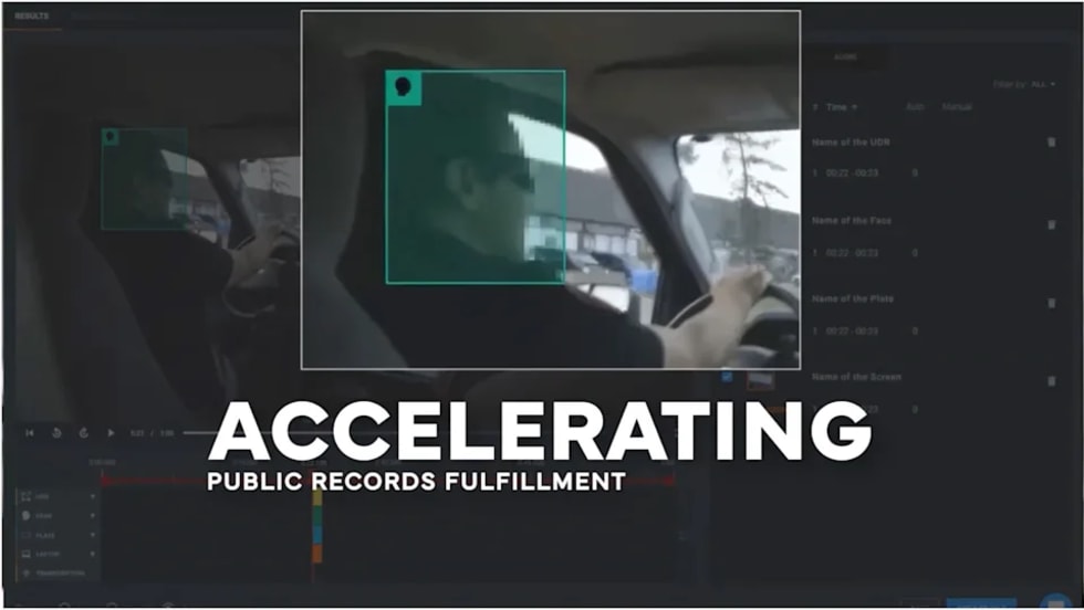
CHP to Accelerate Evidence Redaction & Public Records Fulfillment Through Veritone Redact
With Veritone Redact, the California Highway Patrol can redact video, audio, and image-based evidence, reducing time spent on evidence preparation and public record requests.
Read More →
Echodyne Expands Public Safety Radar Applications Through Partnership with Axon
Echodyne has partnered with Axon to support safer and more scalable drone operations across law enforcement, homeland security, and Drone as First Responder programs globally.
Read More →
Miami Police Department Deploys Airwayz’s Overwatch Platform During FIFA World Cup Events
The deployment of Airwayz’s Overwatch airspace management platform during the FIFA World Cup demonstrates the future of airspace infrastructure for managing, securing, and coordinating complex urban airspace environments.
Read More →
How Patrolfinder Uses Data to Make Streets Safer
Law enforcement agencies have long relied on instinct and routine to optimize patrols. Patrolfinder uses data to help agencies see where officers go — and where they don’t — to improve visibility and maximize coverage.
Read More →
Crime Prevention by Merging Tech with Human Intervention
Elite Interactive Solutions tackles crime prevention with technology and human intervention, working closely with local police to provide insights when a response is needed. The key is to blend the latest in remote video monitoring, artificial intelligence, and a well-trained agent with eyes on the scene.
Read More →
Case Study Details Integration of Body-Worn Cameras with CAD
The Billerica Police Department (Massachusetts) improved transparency and accountability, sharpened evidence management, and reduced manual hours by integrating Axis Communications body-worn cameras with its Computer-Aided Dispatch (CAD) system.
Read More →