

Michigan State Police Upgrades Deepwater Capabilities with Autonomous Underwater Vehicle
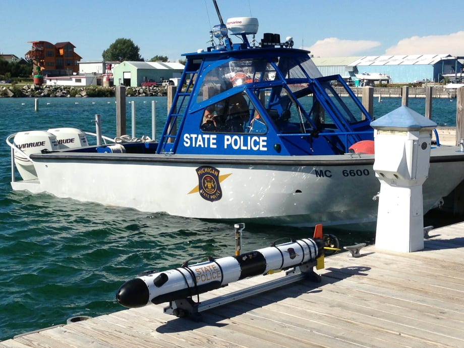
OceanServer Technology recently delivered an Iver3-580 autonomous underwater vehicle (AUV) to the Michigan State Police Underwater Recovery Unit. The AUV system operates at depths to 200 meters and includes EdgeTech’s 2205 high-resolution side scan sonar.
OceanServer Technology recently delivered an Iver3-580 autonomous underwater vehicle (AUV) to the Michigan State Police Underwater Recovery Unit. The AUV system operates at depths to 200 meters and includes EdgeTech’s 2205 high-resolution side scan sonar.
OceanServer has sold more than a dozen systems to customers in the Great Lakes Region, including four systems to the University of Michigan and one Iver3 system shipped to Michigan Tech University in 2013.
The Michigan State Police Underwater Recovery Unit has a lot of water to cover with thousands of inland lakes and shorelines on four of the Great Lakes. The Iver platform will allow the MSP team to rapidly deploy the AUV not only in shallow water but in depths of more than 50 meters where towed sonar systems and diver operations are far more challenging.
AUVs allow users to program fixed lawn mower-style sweeps of wide areas with very little logistical support or cost. The EdgeTech’s 2205 sonar system comes with two frequencies (1600kHz/600kHz) to give investigators the option for very fine resolution or wide area survey capability. AUVs are increasingly being called into service for support in underwater forensics and search and recovery operations.
“It is a real milestone to see this critical technology adopted by the State Police, building on years of collaboration with universities in the state. Michigan’s investment in this technology will greatly expand the Underwater Recovery Unit’s deep water search capability as evidenced during the two recent deployments on two open cases,” OceanServer's president Bob Anderson says.
All Iver AUV models come standard with OceanServer’s VectorMap mission planning and data presentation tool, which provides geo-registered data files that can be easily exported to other software analysis tools. The VectorMap program can input NOAA electronic navigational Charts (ENCs) or any geo-referenced charts, maps or photo images, allowing the operator to intuitively develop AUV missions using simple point-and-click navigation.
The Iver AUV gives university, government, and commercial users an affordable base-platform for sensor development or survey applications in water quality, sub-surface security and general research.
About OceanServer
OceanServer provides OEMs with innovative power solutions, sensors and robotics for a variety of applications. OceanServer's products are designed to be cost effective and easy to integrate into customer equipment. Fully engineered and well-documented subsystems can dramatically reduce time to market and enable new and innovative solutions for real-world application challenges. OceanServer Technology is headquartered in Fall River, MA.
More Technology

Pimloc Launches Secure File Sharing to Streamline Release of Redacted Video
Pimloc’s Secure File Sharing lets organizations deliver redacted video, audio, and documents through expiring, passcode-protected links, accelerating delivery while reducing security, compliance, and chain-of-custody risks.
Read More →
2026 Vision FirstNet Users Summit to Explore How FirstNet Fusion and LMR Are Redefining Mission-Critical Communications
One of the sessions at the 2026 Vision FirstNet Users Summit will highlight hybrid devices bridging broadband and LMR. “Bridging Broadband and LMR: FirstNet Fusion and the Rise of Hybrid Devices” will explore how public safety agencies can modernize their communications environments while maintaining the reliability of land mobile radio.
Read More →
Cellebrite Expands Exclusive SkySafe Partnership to Deliver Immediate Drone Detection and Airspace Intelligence for Digital Investigations at Scale
By integrating SkySafe's drone detection and airspace intelligence with Cellebrite's platform, agencies can connect real-time and historical UAV flight data with mobile forensic evidence, all in one place.
Read More →

New DroneShield Report Reveals Serious Gaps in Airport, Critical Infrastructure Counter-Drone Security
Survey results, as part of “Airspace Under Pressure: A Global Assessment of Counter-UAS Readiness Across Airports and Critical Infrastructure,” indicate that 60% of organizations say they lack legal authority to act against unauthorized drones.
Read More →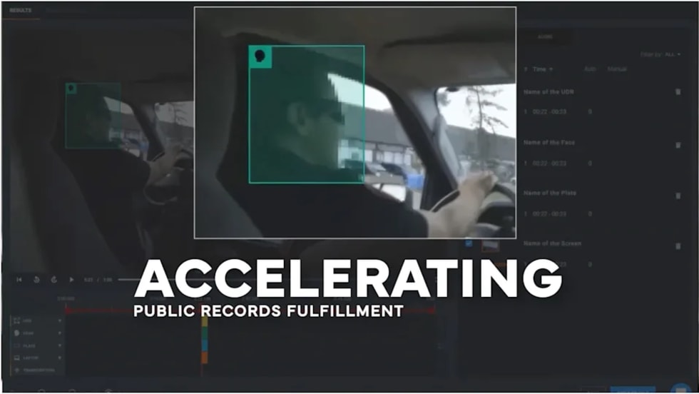
CHP to Accelerate Evidence Redaction & Public Records Fulfillment Through Veritone Redact
With Veritone Redact, the California Highway Patrol can redact video, audio, and image-based evidence, reducing time spent on evidence preparation and public record requests.
Read More →
Echodyne Expands Public Safety Radar Applications Through Partnership with Axon
Echodyne has partnered with Axon to support safer and more scalable drone operations across law enforcement, homeland security, and Drone as First Responder programs globally.
Read More →
Miami Police Department Deploys Airwayz’s Overwatch Platform During FIFA World Cup Events
The deployment of Airwayz’s Overwatch airspace management platform during the FIFA World Cup demonstrates the future of airspace infrastructure for managing, securing, and coordinating complex urban airspace environments.
Read More →
How Patrolfinder Uses Data to Make Streets Safer
Law enforcement agencies have long relied on instinct and routine to optimize patrols. Patrolfinder uses data to help agencies see where officers go — and where they don’t — to improve visibility and maximize coverage.
Read More →
Crime Prevention by Merging Tech with Human Intervention
Elite Interactive Solutions tackles crime prevention with technology and human intervention, working closely with local police to provide insights when a response is needed. The key is to blend the latest in remote video monitoring, artificial intelligence, and a well-trained agent with eyes on the scene.
Read More →
Case Study Details Integration of Body-Worn Cameras with CAD
The Billerica Police Department (Massachusetts) improved transparency and accountability, sharpened evidence management, and reduced manual hours by integrating Axis Communications body-worn cameras with its Computer-Aided Dispatch (CAD) system.
Read More →