



GETAC's Rugged GPS/PDA Features Camera, Altimeter and E-Compass
GETAC's PS535F handheld is the company's next generation, fully rugged GPS-enabled PDA featuring a built-in 3 megapixel auto-focus camera, altimeter, and E-compass. These new features will enable field-based employees to capture field data on-site and transmit that data back to headquarters in real-time.

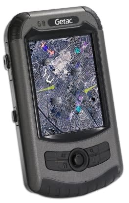
GETAC Inc., a leading innovator and manufacturer of rugged computers that meet the demands of field-based applications, announced the latest addition to its comprehensive line of rugged mobile computing solutions. The GETAC PS535F handheld is the company's next generation, fully rugged GPS-enabled PDA featuring a built-in 3 megapixel auto-focus camera, altimeter, and E-compass.
These new features will enable field-based employees to capture field data on-site and transmit that data back to headquarters in real-time. In addition, the PS535F will provide pinpoint navigation support for improved location-based productivity, which is critical with search-and-rescue missions.
The PS535F handheld PDA is perfectly suited for GIS surveying applications across different sectors. The built-in camera enables instant visual data capture in the field, and the 3.5-inch VGA touch screen display with sunlight readable technology dramatically enhances the viewing quality of graphic-intensive files and detailed maps, even in bright sunlight or snowy conditions.
In addition to its GPS system, the product's built-in altimeter and E-compass provide advanced navigation features such as fixed positioning of longitude, latitude, and altitude, as well as the ability to provide directional relations between the targeted subject and the user's position.
The PS535F also features comprehensive wireless connectivity options, including integrated Bluetooth V2.0 and 802.11b/g WiFi. Users can connect the PS535F to a GIS server and instantly transmit or process data in the field using a GETAC Bluetooth modem or mobile phone.
"Our customers typically work in high-intensity environments and situations, which demand seamless and accurate information exchange between the main office and field workers," said Jim Rimay, president, GETAC. "The PS535F is the ideal solution for any field application that requires immediate response and action such as fire and rescue teams and park rangers. A great example is forest patrols reporting the location and fire hazard conditions to a fire center to assist fire rescue planning.
Ultimately, GETAC's PS535F handheld device improves overall operational efficiencies and productivity, which can be a lifesaving feature."
The GETAC PS535F features Windows Mobile 6.1 software for quick access to e-mail, the Internet, texting, and other means of mobile communications.
Weighing a mere 10.7 ounces, the device can operate at full capacity for up to 8 hours on a fully charged battery and is MIL-STD 810F compliant and IP54 certified to operate without failure under the most extreme weather conditions, environments, and everyday abuse associated with its user base.
Getac PS535F Main Features:
3.5-inch VGA Touch Screen Display
533MHz Samsung 2450 processor
Microsoft Windows Mobile 6.1
128Mb onboard MDDR
2GB onboard NAND Flash Storage ROM
MIL-STD 810F and IP54 compliant
Embedded GPS Receiver
3.0 Megapixel On-Board Camera
Altimeter and E-Compass
Integrated Bluetooth V2.0 and 802.11b/g capability
Sunlight Readable Display solution (optional)
8-Hour Battery Life
Dimensions: 5.7 x 3.2 x 1.2 inches
Weight: 10.6 ounces
About GETAC
GETAC, Inc., A subsidiary of MiTAC Technology Corporation, was founded in
1989 as a joint venture with GE Aerospace and has been a pioneer and innovator in the rugged mobile computing industry ever since. GETAC provides premier fully rugged, rugged and semi-rugged notebook, tablet PC and handheld solutions for the military, law enforcement, public safety, utility, telecommunication, manufacturing, field service and mobile workforce industries. All GETAC rugged models are strictly controlled and monitored from the design, manufacture, quality assurance to service flows, making GETAC an industry-preferred rugged computer provider.
For more information, visit www.getac.com.
More Technology

How Motorola Solutions’ New “Insights” Platform Helps Public Safety Agencies Identify Trends to Improve Their Operations
Motorola Solutions has introduced Insights, which leverages Assist, its mission-critical artificial intelligence (AI), to address these challenges and shape what’s next for public safety analytics and reporting technology.
Read More →
What Qualifies a Laptop as Rugged or Fully Rugged?
Police officers face a wide range of working conditions that can damage or even destroy a regular consumer laptop. Learn what qualifies a computer as rugged or fully rugged and why those devices are vital for law enforcement.
Read More →
Panasonic Connect Launches the Toughbook 34 and Toughbook G3, Fully Rugged 2-in-1 Mobile Computers
Panasonic Connect has launched the Toughbook 34 and Toughbook G3 to facilitate in-vehicle dispatch, records management, and mobile command operations from any location.
Read More →

A police agency's guide to data-driven fleet management
Costs are rising and the public expects more transparency into how their tax dollars are spent. This e-book shows how police agencies can use fleet data to take control of fleet expenses while improving officer safety and demonstrating fiscal responsibility to the communities they serve.
Read More →
AI and analytics for law enforcement: Turning data into insights
Law enforcement agencies are managing more video, sensor data and digital evidence than ever before. Discover how AI and analytics can help turn that data into actionable insights that strengthen situational awareness, accelerate investigations and support more informed decisions.
Read More →
Vasco Electronics Adds Automatic Language Detection to Vasco Translator Q1
Vasco Electronics’ software update introduces hands-free language switching and expanded offline translation across 45 language pairs, empowering law enforcement, healthcare, and front-office enterprise teams
Read More →
North Miami Police Department Deploys Mark43
The North Miami Police Department has deployed Mark43 as part of its Five-Year Strategic Plan that represents its collective vision and goals for a more proactive police department, anchored by a core commitment to leveraging modern technology to enhance efficiency and public safety.
Read More →
Cellebrite Genesis for Enterprise Now Generally Available
Made available to the public sector in June, Cellebrite Genesis is serving a growing mix of national, regional, and local agencies worldwide, including some of the largest regional and metropolitan police departments. It is now available for enterprise organizations.
Read More →
2026 Vision FirstNet Users Summit to Host Emerging Leaders Training on Grassroots Advocacy for Public Safety
“Emerging Leaders Training: Understanding the Importance of Grassroots Advocacy for Public Safety," a session during the 2026 Vision FirstNet Users Summit, will offer a roadmap for unified advocacy at the federal level.
Read More →
Motorola Solutions Completes Acquisition of D-Fend Solutions
Motorola Solutions has acquired D-Fend Solutions, an industry leader in counter-drone technology. This deal provides public safety and enterprise customers with access to advanced counter-unmanned aerial systems.
Read More →