

Esri, Geofeedia Add Social Media Analytics to Mapping Software
Esri announced a partnership to incorporate Geofeedia's social media tools into its ArcGIS mapping platform to assist law enforcement during emergency events. The upgrade will give public safety professionals the capability to accurately integrate, monitor, analyze, and visualize live emergency data as events unfold.
Esri announced a partnership to incorporate Geofeedia's social media tools into its ArcGIS mapping platform to assist law enforcement during emergency events.
The upgrade will give public safety professionals the capability to accurately integrate, monitor, analyze, and visualize live emergency data as events unfold.
"Esri is an industry leader and provides the ideal enterprise platform to visualize and analyze real-time social media feeds from Geofeedia," said Phil Harris, Geofeedia's CEO. "Location-based social media data layers from Geofeedia combined with Esri's technology and vast repository of other layers give public safety officials the best combination of real-time intelligence for response efforts."
The real-time data integration, searching and streaming will work across multiple social media platforms including Twitter, Instagram, Flickr, YouTube, and Picasa. Geo-located tweets, photos, and videos can be viewed within the context of digital imagery, street networks, topography, and community base maps. The social data can be mashed up with other information such as public safety assets, city infrastructure, utility networks, hazardous materials, and demographic data.
Additional dynamic data including weather, automated vehicle location, GPS, and traffic video camera feeds can be combined with social and map data. In addition, officers can perform historical social media analysis to identify trends and patterns.
More Technology

Cellebrite Expands Exclusive SkySafe Partnership to Deliver Immediate Drone Detection and Airspace Intelligence for Digital Investigations at Scale
By integrating SkySafe's drone detection and airspace intelligence with Cellebrite's platform, agencies can connect real-time and historical UAV flight data with mobile forensic evidence, all in one place.
Read More →
New DroneShield Report Reveals Serious Gaps in Airport, Critical Infrastructure Counter-Drone Security
Survey results, as part of “Airspace Under Pressure: A Global Assessment of Counter-UAS Readiness Across Airports and Critical Infrastructure,” indicate that 60% of organizations say they lack legal authority to act against unauthorized drones.
Read More →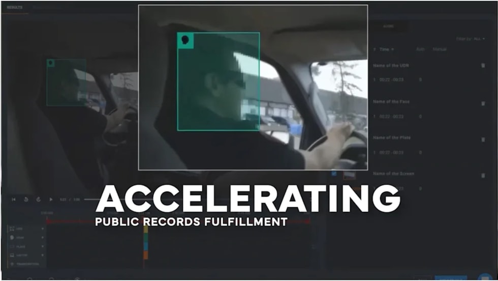
CHP to Accelerate Evidence Redaction & Public Records Fulfillment Through Veritone Redact
With Veritone Redact, the California Highway Patrol can redact video, audio, and image-based evidence, reducing time spent on evidence preparation and public record requests.
Read More →

Echodyne Expands Public Safety Radar Applications Through Partnership with Axon
Echodyne has partnered with Axon to support safer and more scalable drone operations across law enforcement, homeland security, and Drone as First Responder programs globally.
Read More →
Miami Police Department Deploys Airwayz’s Overwatch Platform During FIFA World Cup Events
The deployment of Airwayz’s Overwatch airspace management platform during the FIFA World Cup demonstrates the future of airspace infrastructure for managing, securing, and coordinating complex urban airspace environments.
Read More →
How Patrolfinder Uses Data to Make Streets Safer
Law enforcement agencies have long relied on instinct and routine to optimize patrols. Patrolfinder uses data to help agencies see where officers go — and where they don’t — to improve visibility and maximize coverage.
Read More →
Crime Prevention by Merging Tech with Human Intervention
Elite Interactive Solutions tackles crime prevention with technology and human intervention, working closely with local police to provide insights when a response is needed. The key is to blend the latest in remote video monitoring, artificial intelligence, and a well-trained agent with eyes on the scene.
Read More →
Case Study Details Integration of Body-Worn Cameras with CAD
The Billerica Police Department (Massachusetts) improved transparency and accountability, sharpened evidence management, and reduced manual hours by integrating Axis Communications body-worn cameras with its Computer-Aided Dispatch (CAD) system.
Read More →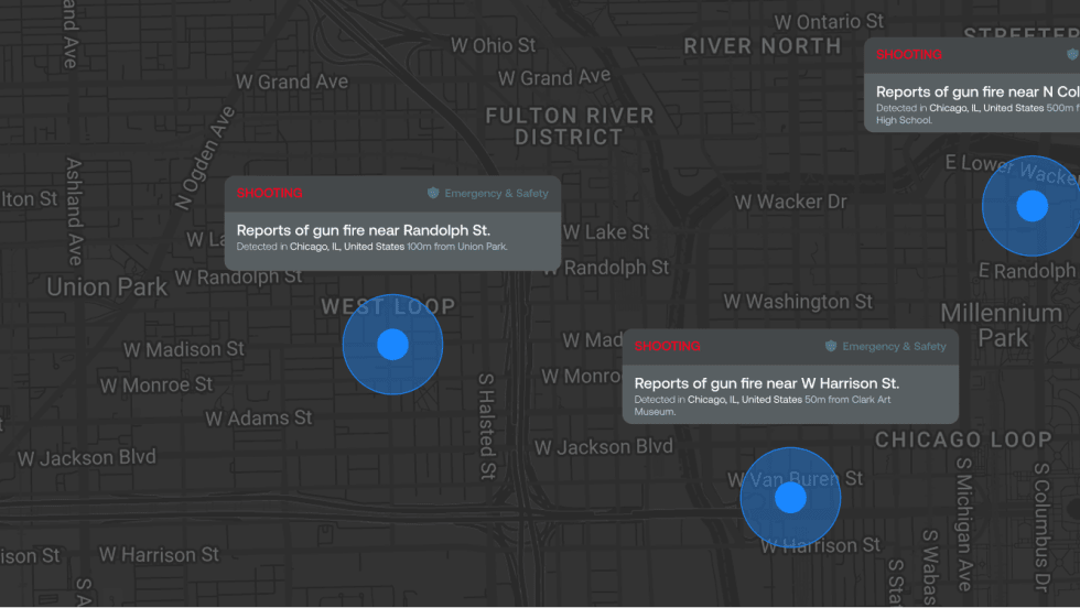
ZeroEyes Public Safety Alerts Integrates Samdesk for Real-Time Risk Detection and Awareness
ZeroEyes has integrated Samdesk into its Public Safety Alerts platform to deliver faster, verified intelligence to help organizations understand emerging risks and respond quickly.
Read More →
NJ Police Department Combines Strong Technology & Public Safety Strategy
The Fort Lee Police Department in New Jersey has modernized with Genetec Security Center, including video management, automatic license plate recognition (ALPR), and Clearance digital evidence management.
Read More →