

My Technology Can…Leverage Data to Reduce Traffic Accidents
Using the analytic features provided by LexisNexis Crash Mapper and Dashboards, law enforcement agencies can make the roads safer.
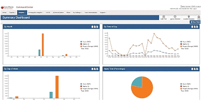
Robust dashboards in LexisNexis’ Crash Mapper can reveal accident and traffic-safety issues and trends by multiple causation factors.
Communities and organizations across the country are mobilizing and organizing toward a goal of zero traffic fatalities by the year 2050. This effort couldn’t be more timely. After a year of covid-19 lockdowns and restrictions, more states are now beginning to reopen and return to a more business-as-usual posture, which will bring increasing traffic. More traffic may bring more traffic-related incidents and, unfortunately, fatalities. Lexisnexis coplogic solutions is committed to providing solutions that can help agencies drive closer toward the zero fatality vision.
The Problem
Despite less traffic during 2020 due to reduced travel during the COVID-19 pandemic, instances of driving violations classified as “major” were higher for the year. According to LexisNexis internal data, although fewer miles were driven due to widespread lockdowns, high-speed driving and hard braking incidences were above expectations and normal levels. According to the National Highway Traffic Safety Administration, traffic fatality rates were up 4.6% from 2019.
Law enforcement agencies play a critical role in saving lives on U.S. roadways. However, many lack the ability to quickly see when, where, and why traffic accidents are occurring, creating challenges to effectively address the situation. This lack of data can leave agencies stuck in reactive mode, limiting their ability to plan proactively for future traffic accidents and resulting in increased personnel hours as command staff often manually scour through pages of crash report data to produce reports.
The Solution
At LexisNexis Coplogic Solutions, we believe a proactive approach to traffic safety can be created and driven by the adoption of more advanced data and analytics programs. Data sophistication is the process that applies a uniform, automated approach to unstructured, basic data collection to support real-time data integration, making it easier to apply those insights to real-world issues. Access to accurate, timely crash information that can be used to generate actionable insights can lead to traffic safety improvements.
Agencies across the country leverage varying degrees of data sophistication. Many are still paper-based in their approach to crash reporting or if they do have an electronic process in place, they aren’t able to access dynamic crash analytics in real-time and in a way that enables advanced data visualization that can pinpoint traffic safety issues and hotspots for the implementation of proactive, preventative measures.
LexisNexis Coplogic Solutions can help by delivering advanced, actionable data and analytics. The Crash Mapper and Dashboards are valuable tools for law enforcement that link command staff and the traffic division to digitized crash reports, making it easier to get just-in-time insights that inform decision making. Agencies can build at-a-glance views of mission-critical crash statistics, including crash counts from several categories. They also can switch from street views, satellite views, heat maps, and points overlay, as well as add points of interest. The free features included with our crash solutions can enable law enforcement agencies to develop a strategic traffic safety program suited for their community’s specific needs.
These tools make it possible for agencies to go from proactive to predictive. For example, if a certain intersection is the site of frequent accidents, the agency can work with the city to install crosswalks, traffic lights or other remedies to help reduce future accidents in that area.
Easy-to-Use Dashboards: The easy-to-use Dashboards feature includes multiple dashboards that highlight accident and traffic trends by cause, age, and other factors that offer a better understanding of the root causes of different incidents, including distracted driving and other types of violations. The Dashboards also can sort data by time of day and weather conditions. The ability to sort by cause and weather condition is a vital feature, as it allows agencies to determine if a long-term problem exists in that area or if the incident was subject to external factors, such as inclement weather. The reports can easily be downloaded into PDF or Excel for emailing or later use.
Maintaining Transparency with the Community: Now more than ever, it is extremely important for law enforcement agencies to maintain positive relationships with the communities they serve. The Crash Mapper and Dashboards make transparency as easy as the click of a button. Agencies can use reports to inform citizens about the proactive steps law enforcement agencies are taking to make the roads safer for citizens, as well as alert them to potential road hazards. Crash Mapper and Dashboards empower agencies with the ability to provide targeted, near real-time data for neighborhood meetings and command staff reviews.
Quickly Identify and Correct Traffic Safety Issues: With Crash Mapper and Dashboards, agencies can pinpoint where, when, and why accidents happen and intelligently deploy patrols based on peak or recurring activity, leading to effective use of resources and staffing. Additionally, agencies can access detailed crash statistics to support federal grant applications or special initiatives.
One Size Does Not Fit All: No matter how big or small an agency is or where they are in their crash data automation journey, LexisNexis Coplogic Solutions has the experience and know-how to bridge the gap so every agency can increase data sophistication and advance their traffic safety strategy. Crash Mapper and Dashboards equip agencies with easy-to-use yet powerful analytics that will be instrumental in getting communities across America one step closer to meeting the goal of zero fatalities by 2050. Crash Mapper and Dashboards are free to agencies when they leverage either the LexisNexis eCrash or LexisNexis BuyCrash solution.
Roy Marler is vice president of product management for LexisNexis Coplogic solutions.
More Technology

Cellebrite Expands Exclusive SkySafe Partnership to Deliver Immediate Drone Detection and Airspace Intelligence for Digital Investigations at Scale
By integrating SkySafe's drone detection and airspace intelligence with Cellebrite's platform, agencies can connect real-time and historical UAV flight data with mobile forensic evidence, all in one place.
Read More →
New DroneShield Report Reveals Serious Gaps in Airport, Critical Infrastructure Counter-Drone Security
Survey results, as part of “Airspace Under Pressure: A Global Assessment of Counter-UAS Readiness Across Airports and Critical Infrastructure,” indicate that 60% of organizations say they lack legal authority to act against unauthorized drones.
Read More →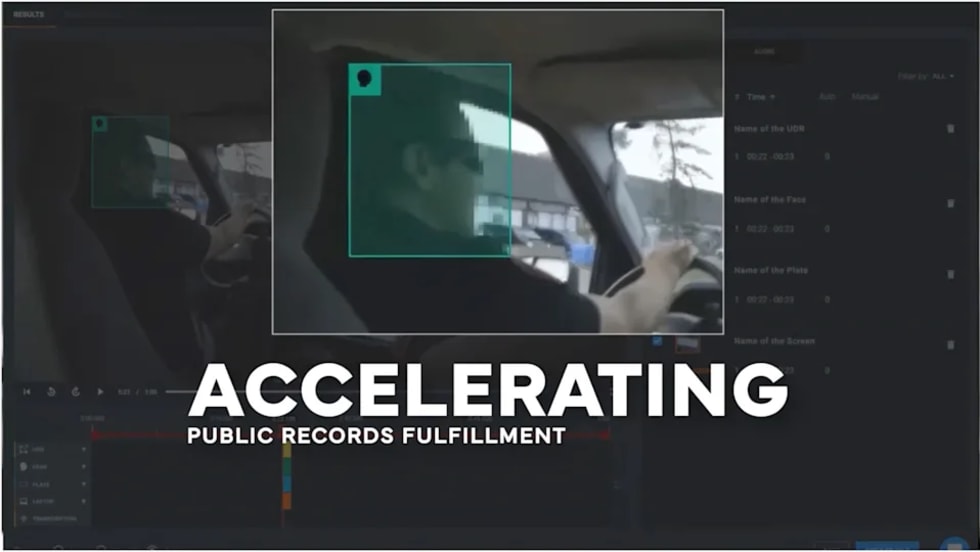
CHP to Accelerate Evidence Redaction & Public Records Fulfillment Through Veritone Redact
With Veritone Redact, the California Highway Patrol can redact video, audio, and image-based evidence, reducing time spent on evidence preparation and public record requests.
Read More →
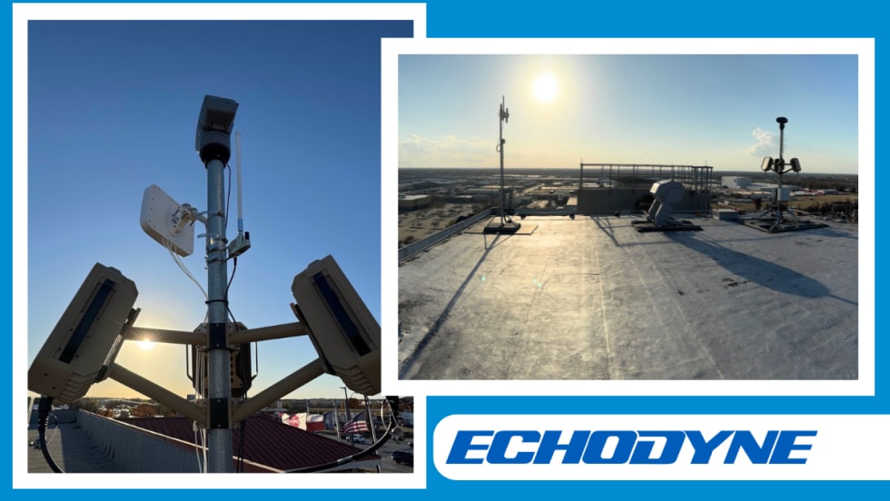
Echodyne Expands Public Safety Radar Applications Through Partnership with Axon
Echodyne has partnered with Axon to support safer and more scalable drone operations across law enforcement, homeland security, and Drone as First Responder programs globally.
Read More →
Miami Police Department Deploys Airwayz’s Overwatch Platform During FIFA World Cup Events
The deployment of Airwayz’s Overwatch airspace management platform during the FIFA World Cup demonstrates the future of airspace infrastructure for managing, securing, and coordinating complex urban airspace environments.
Read More →
How Patrolfinder Uses Data to Make Streets Safer
Law enforcement agencies have long relied on instinct and routine to optimize patrols. Patrolfinder uses data to help agencies see where officers go — and where they don’t — to improve visibility and maximize coverage.
Read More →
Crime Prevention by Merging Tech with Human Intervention
Elite Interactive Solutions tackles crime prevention with technology and human intervention, working closely with local police to provide insights when a response is needed. The key is to blend the latest in remote video monitoring, artificial intelligence, and a well-trained agent with eyes on the scene.
Read More →
Case Study Details Integration of Body-Worn Cameras with CAD
The Billerica Police Department (Massachusetts) improved transparency and accountability, sharpened evidence management, and reduced manual hours by integrating Axis Communications body-worn cameras with its Computer-Aided Dispatch (CAD) system.
Read More →
ZeroEyes Public Safety Alerts Integrates Samdesk for Real-Time Risk Detection and Awareness
ZeroEyes has integrated Samdesk into its Public Safety Alerts platform to deliver faster, verified intelligence to help organizations understand emerging risks and respond quickly.
Read More →
NJ Police Department Combines Strong Technology & Public Safety Strategy
The Fort Lee Police Department in New Jersey has modernized with Genetec Security Center, including video management, automatic license plate recognition (ALPR), and Clearance digital evidence management.
Read More →