



First Look: Emergency Incident System
Aegix Global’s aim allows schools, facilities and events to call for help during critical situations, provide responders with essential information, and enable direct two-way communication between users and safety personnel on site.


Aegix AIM can operate on Apple and Windows computers and iOS and Android devices.
When you’re best known for designing a folding ballistic shield, it can be quite a challenge to pivot to also produce emergency alert software, but that’s exactly what Aegix Global has done with its new Aegix AIM.
Aegix CEO Chet Linton says the company’s relationships with schools that have purchased its Swift Shield as ballistic protection for students and staff along with his background in technology and education made the acquisition and ongoing development of the AIM (Active Incident Management) software platform a natural next step for Aegix.
AIM is a tool designed to improve direct two-way communication between people inside a school or other buildings and facilities during a time of emergency such as an active shooter situation, natural disaster, fire, or any critical incident. AIM also alerts safety personnel an emergency is occurring. It allows dispatchers and responders the ability to communicate with the people involved in the incident , records all messages sent by users, and provides critical information for emergency personnel arriving on scene.
AIM clients are school systems, campuses, hospitals, and other public and private entities that may be targeted by a shooter or need assistance from first responders during an emergency. Public safety agencies, including police departments, that would respond to aid the Aegix clients, receive AIM for free through the Aegix Humanitarian FoundationH.
One of the features of AIM is that first responders can access maps and floor plans of all the buildings the customer wants Aegix to include in the system. They can also pinpoint the locations of individuals in the building. “We have an interactive map of the building with details of every floor,” Linton says. “When officers enter the building, they have a live map that shows the location of people who have indicated whether they need medical attention and whether they feel safe or unsafe.”
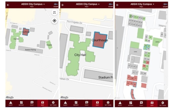
AIM provides live maps to first responders that law enforcement can use for tactical awareness.
Instantly having access to information about the building and where people need help can save time and lives, Linton says. “I was talking to one chief about maps and he told me there is a central repository of maps of all the buildings in his city, but he said it takes at least 15 minutes to find the right maps or floor plans. So when his officers arrive at the school, facility or event during an emergency, they don’t have the plans. AIM solves that problem,” he explains.
Because the maps in AIM are live, they not only show the locations of people inside the facility, they can also be updated for real-time tactical reasons, for example, when rooms have been cleared. This critical information can be limited to police-only access. Responding officers can also receive photos, videos, and other intelligence from the people in the building who have AIM.
AIM enables officers to communicate directly with people in the building. For example, during a school shooting incident, an officer can call or text a specific teacher or staffer through the AIM platform.
Because AIM is a cloud-based platform, Aegix can constantly provide new features for clients. . One of the newest AIM features is administrative approval. When someone initiates an alert showing an emergency situation is in progress, it must be approved by an “administrator” before it alerts the other people on the channel and summons emergency responders. “Several clients wanted this feature so they could eliminate false alerts,” Linton says.
Aegix AIM is in use in several hundred locations around the United States. It runs on Windows and Apple operating systems and on Android and iOS mobile devices. AIM users pay an annual subscription price. Linton says most clients sign up for five years. There is also an initial set-up fee that is based on the number of buildings that the client wants to cover.
More Technology

Panasonic Connect Launches the Toughbook 34 and Toughbook G3, Fully Rugged 2-in-1 Mobile Computers
Panasonic Connect has launched the Toughbook 34 and Toughbook G3 to facilitate in-vehicle dispatch, records management, and mobile command operations from any location.
Read More →
A police agency's guide to data-driven fleet management
Costs are rising and the public expects more transparency into how their tax dollars are spent. This e-book shows how police agencies can use fleet data to take control of fleet expenses while improving officer safety and demonstrating fiscal responsibility to the communities they serve.
Read More →
AI and analytics for law enforcement: Turning data into insights
Law enforcement agencies are managing more video, sensor data and digital evidence than ever before. Discover how AI and analytics can help turn that data into actionable insights that strengthen situational awareness, accelerate investigations and support more informed decisions.
Read More →

Vasco Electronics Adds Automatic Language Detection to Vasco Translator Q1
Vasco Electronics’ software update introduces hands-free language switching and expanded offline translation across 45 language pairs, empowering law enforcement, healthcare, and front-office enterprise teams
Read More →
North Miami Police Department Deploys Mark43
The North Miami Police Department has deployed Mark43 as part of its Five-Year Strategic Plan that represents its collective vision and goals for a more proactive police department, anchored by a core commitment to leveraging modern technology to enhance efficiency and public safety.
Read More →
Cellebrite Genesis for Enterprise Now Generally Available
Made available to the public sector in June, Cellebrite Genesis is serving a growing mix of national, regional, and local agencies worldwide, including some of the largest regional and metropolitan police departments. It is now available for enterprise organizations.
Read More →
2026 Vision FirstNet Users Summit to Host Emerging Leaders Training on Grassroots Advocacy for Public Safety
“Emerging Leaders Training: Understanding the Importance of Grassroots Advocacy for Public Safety," a session during the 2026 Vision FirstNet Users Summit, will offer a roadmap for unified advocacy at the federal level.
Read More →
Motorola Solutions Completes Acquisition of D-Fend Solutions
Motorola Solutions has acquired D-Fend Solutions, an industry leader in counter-drone technology. This deal provides public safety and enterprise customers with access to advanced counter-unmanned aerial systems.
Read More →
ZeroEyes, Advantech & Camden Police Partner to Bring AI Gun Detection Technology to Delaware School District
ZeroEyes has partnered with Advantech and the Camden Police Department to deploy ZeroEyes’ AI gun detection and intelligent situational awareness platform at Delaware’s Caesar Rodney School District (CRSD).
Read More →
Leonardo U.S. Cyber & Security Solutions Introduces SignalTrace, the Next Evolution in Electronic Signature Detection Technology
SignalTrace reflects years of product refinement and a clearer expression of the technology’s purpose of recognizing and correlating electronic signatures in publicly broadcast wireless signals to reveal patterns, relationships, and trends that might otherwise go undetected.
Read More →