



Helinet Technologies Brings Aerial Surveillance Video to Mobile Devices
Breakthrough capability from Helinet Technologies allows ground personnel to view encrypted, real-time aerial video feeds on their BlackBerry and Windows Mobile Smartphones.

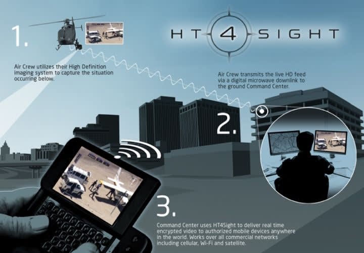
Helinet Technologies' HT 4Sight allows officers to view live aerial surveillance video on their smartphones.
Helinet Technologies, the aerial surveillance solutions division of Helinet Aviation, announced the launch of HT 4Sight, a mobile technology solution to allow ground-based personnel to view live, encrypted video feeds on their mobile devices.
The breakthrough capability builds upon the division's pioneering work in deploying advanced microwave downlink systems to enable ship-to-ground transmission of live, broadcast quality video for major law enforcement and government agencies including the Los Angeles Police Department, DEA, and various national and international military organizations.
With HT 4Sight, Helinet Technologies takes that transmission functionality outside of a ground-based receive site setting to allow users to view the video wherever they receive mobile service - even from thousands of miles away.
Available for a wide variety of BlackBerry and Windows Mobile devices, HT 4Sight works on all commercial networks, including cellular, Wi-Fi, and satellite. The new capability enhances the ability of ground personnel to accurately assess and respond to crisis situations by providing them with anywhere, anytime access to real time intelligence. Users can monitor an unlimited number of live video feeds on a single device, allowing them to manage large scale surveillance operations comprised of multiple camera systems operating simultaneously. Additionally, HT 4Sight allows users to take active control of the remote cameras in their system to direct the zoom, tilt and pan functions all from their handheld device.
"Through our close working relationships with law enforcement, government agencies, and military organizations as well as our experience providing live, aerial solutions for all of the major television networks, we've had the opportunity to develop some of the most robust live, downlink capabilities in the industry," said Ron Magocsi, vice president, chief technical officer, for Helinet Technologies.
"HT 4Sight represents the natural next step in real-time transmission of critical aerial surveillance video footage, improving the ability of law enforcement and government to preserve the public's safety. With HT 4Sight, soldiers, officers, and commanders are now better equipped to make split-second tactical decisions no matter where they happen to be."
With a strong understanding of the varying requirements of agencies across the law enforcement and government spectrum, Helinet Technologies is able to quickly create and deploy aerial surveillance packages and solutions such as HT 4Sight to organizations across the globe.
Backed by decades of experience at the forefront of the aerial surveillance and network broadcasting industries, the firm offers a flexible, customer driven approach with services ranging from basic equipment sales to fully outsourced surveillance solutions, including providing pilots and aircraft.
For more information call (818) 902-0229.
About Helinet Aviation Services
Helinet Aviation Services is an international provider of aviation services to a diversity of markets. Founded in 1987 and based in Van Nuys, Calif., the company serves clients in the broadcasting, government, law enforcement, medical, motion picture, and transportation industries.
More Technology

How Motorola Solutions’ New “Insights” Platform Helps Public Safety Agencies Identify Trends to Improve Their Operations
Motorola Solutions has introduced Insights, which leverages Assist, its mission-critical artificial intelligence (AI), to address these challenges and shape what’s next for public safety analytics and reporting technology.
Read More →
What Qualifies a Laptop as Rugged or Fully Rugged?
Police officers face a wide range of working conditions that can damage or even destroy a regular consumer laptop. Learn what qualifies a computer as rugged or fully rugged and why those devices are vital for law enforcement.
Read More →
Panasonic Connect Launches the Toughbook 34 and Toughbook G3, Fully Rugged 2-in-1 Mobile Computers
Panasonic Connect has launched the Toughbook 34 and Toughbook G3 to facilitate in-vehicle dispatch, records management, and mobile command operations from any location.
Read More →

A police agency's guide to data-driven fleet management
Costs are rising and the public expects more transparency into how their tax dollars are spent. This e-book shows how police agencies can use fleet data to take control of fleet expenses while improving officer safety and demonstrating fiscal responsibility to the communities they serve.
Read More →
AI and analytics for law enforcement: Turning data into insights
Law enforcement agencies are managing more video, sensor data and digital evidence than ever before. Discover how AI and analytics can help turn that data into actionable insights that strengthen situational awareness, accelerate investigations and support more informed decisions.
Read More →
Vasco Electronics Adds Automatic Language Detection to Vasco Translator Q1
Vasco Electronics’ software update introduces hands-free language switching and expanded offline translation across 45 language pairs, empowering law enforcement, healthcare, and front-office enterprise teams
Read More →
North Miami Police Department Deploys Mark43
The North Miami Police Department has deployed Mark43 as part of its Five-Year Strategic Plan that represents its collective vision and goals for a more proactive police department, anchored by a core commitment to leveraging modern technology to enhance efficiency and public safety.
Read More →
Cellebrite Genesis for Enterprise Now Generally Available
Made available to the public sector in June, Cellebrite Genesis is serving a growing mix of national, regional, and local agencies worldwide, including some of the largest regional and metropolitan police departments. It is now available for enterprise organizations.
Read More →
2026 Vision FirstNet Users Summit to Host Emerging Leaders Training on Grassroots Advocacy for Public Safety
“Emerging Leaders Training: Understanding the Importance of Grassroots Advocacy for Public Safety," a session during the 2026 Vision FirstNet Users Summit, will offer a roadmap for unified advocacy at the federal level.
Read More →
Motorola Solutions Completes Acquisition of D-Fend Solutions
Motorola Solutions has acquired D-Fend Solutions, an industry leader in counter-drone technology. This deal provides public safety and enterprise customers with access to advanced counter-unmanned aerial systems.
Read More →