Side-Scan Sonar Identifies N.Y. Crash Evidence

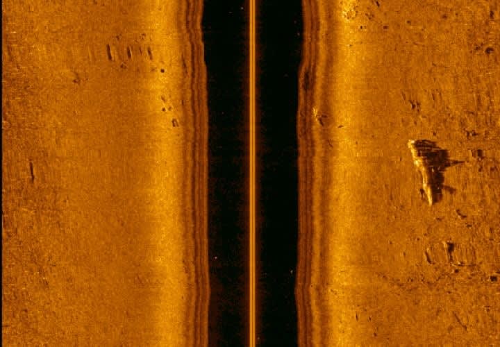
Side-scan sonar is known as a "towfish" — it's a torpedo-like device towed behind a boat. The towfish converts acoustic sound pulses into a video image of the river bottom. To a trained operator, the resulting image offers a photographic view of the bottom that can be used to identify items of interest.

Paul Clinton Web Headshot

A multi-agency task force used side-scan sonor to recover critical debris from the fatal mid-air collision of a small plane and a helicopter over the Hudson River earlier this month.

The area of the Hudson where the plane's fuselage entered the water on Aug. 8 represented the most dangerous elements that an evidence recovery diver could face — deep water, shifting currents, zero visibility, and entanglement hazards.

Earlier in the year, they had recovered a lost engine from US Airways' Flight 1549 after its emergency landing in the river after striking a flock of geese.

Side-scan sonar is known as a "towfish" — it's a torpedo-like device towed behind a boat. The towfish converts acoustic sound pulses into a video image of the river bottom. To a trained operator, the resulting image offers a photographic view of the bottom that can be used to identify items interest, according to an FBI release.

Side-scan systems can cover large swaths of water in fairly short periods, typically a square mile per day. They can also provide clarity in zero-visibility conditions when the murkiness of the water makes it impossible for divers to see with their eyes.

Watch a clip of the sonor video, released by the FBI.

The state police team reviewed many hours of side-scan data they gathered after the crash and provided FBI divers with a general location of what looked like the fuselage of a small plane. On Aug. 9, the agency deployed a sector-scan system to verify the target and to identify its location.

Sector-scan sonar also uses sound pulses to create a visual image. The difference between the two systems is that sector-scan sonar is housed in a six-foot-high tripod that is lowered to the river bottom. Once it is stationary, a transducer rotates in a 360-degree path to paint a real-time picture of the immediate surroundings. Since the location of the tripod is known, precise GPS points can be plotted from the surface.

This sonar can also show the position of a diver, who can then be directed to a specific target through underwater communications systems. In this case, the FBI sonar operator located the same object that was scanned by the state police sonar operator and was able to direct a diver — despite a strong current and zero visibility — to the wreckage.

Once the plane was identified, the team turned its efforts to marking the wreckage for recovery. To accomplish this without risking a diver in high current, the sector scan was utilized again. After a dozen or more attempts, we deployed the tripod successfully, and state police divers were able to drag a large weight alongside the plane. They were then able to provide a direct line from the plane to the surface. An Army Corps of Engineers' crane was used to lift the wreckage from the water.

In the end, the multi-agency effort that included the New Jersey State Police and New York Police Department, led to the safe and successful recovery of the wreckage and of the remains of the victims of this tragedy.

About the Author
Paul Clinton Web Headshot
Web Editor
View Bio
Page 1 of 10
Next Page