

My Technology Can: Put Next Gen 911 in Your Hands
RapidDeploy’s Lightning delivers call data and critical intelligence directly to first responders’ mobile devices.
In the face of dynamic and increasingly complex emergencies, it's become crystal clear: emergency response must evolve. And the power of the cloud is at the heart of this evolution. The digital age has ushered in a new set of expectations for emergency response—where precision, immediacy, and diversified communication channels are now expected, especially when lives are on the line.
By harnessing the power of the cloud’s resiliency and scale, and pushing the boundaries of lifesaving technology, we can build technology that ensures all responders—from telecommunicators and dispatchers inside the call center to those in the field across law enforcement, fire, and EMS—have access to the data they need to save lives. This data superpower strengthens agencies with greater communication, efficient coordination, and more effective response throughout the unified 911 workflow.
The next wave of Next Generation 911 (NG911) solutions is shaping a new future for emergency response, backed by the secure sharing of information, enhanced situational awareness, and greater access to real-time intelligence throughout the emergency response journey—from within the Emergency Communication Centers (ECCs) and Public Service Answering Points (PSAPs) into the field.
THE PROBLEM
Public safety has had limited access to real-time, critical emergency information, which has created siloed communication and coordination across agencies and related departments. This has resulted in less effective incident response. And in pivotal moments, disconnected tools and siloed data can spell the difference between success and tragedy.
Although we have witnessed an industrywide effort to transition away from traditional, analog infrastructures and toward Next Generation 911, much of the tech stack today will not support the continued innovation needed for the future of public safety.
Current first responder technology can consist of a radio, internet via the router in the trunk, mobile data terminals, automated vehicle location, and more. However, it has not been easy to innovate on top of these solutions in a way that supports the transition to NG911, and responders often find it difficult to manage all of their disparate tech. Simply put, the current tech stack does not meet the profession’s need for streamlined, integrated 911 workflows, the secure and efficient sharing of essential information, ease of communication. and the continuous adoption of modern applications such as live video and text capabilities.
Today, field responders have not had access to the same level of real-time information as 911 call takers, limiting their direct access to situational awareness, impacting accurate and efficient incident response, and creating barriers for unit safety.
Greater information sharing is particularly important for unit safety and efficient and effective response, from last known location to breadcrumbs that help track the caller and provide responders with location details when the scene is moving.
Without changing the way critical information is shared with the field, we cannot recognize the true potential of cloud.
THE SOLUTION
By taking the power of a cloud-native primary call-taking map, and extending it to the field, within a secure, mobile app, we can break through agency and departmental siloes and optimize the way information is shared across all responders. That's what RapidDeploy's app called Lightning can do.
Powered by RapidDeploy’s Radius Mapping solution, Lightning delivers 911 call data and critical intelligence directly to first responders’ devices, including smartphones and tablets. Lightning is built for field responders and unifies mapping layers, location accuracy, situational awareness, and modern communications into a single handheld device.
The ability to have a mobile app deliver accurate locations, provide life-saving information, and facilitate the necessary communication platforms to all (police, fire, highway patrol, EMS, volunteer fire, and others) democratizes public safety. Regardless of where you are (from rural areas to suburban or urban regions), and the size of your agency, Lightning can make sure that every responder has access to the critical response capabilities and actionable intelligence they need to save lives.
As 911 calls come into the call center, Lightning receives the precise location and contextual awareness from the call and directly delivers mission critical information to field responder devices. As a result, field responders are not just informed; they are empowered to resolve the situation with mission critical response capabilities that support team safety and improve emergency response outcomes.
Some of the vital tools and intelligent information within Lightning includes:
Device-based location with breadcrumbs
911 calls and responder proximity
Native navigation
Live streaming video
CCTV viewing
Supplemental data including, vehicle telematics data, vehicle cut sheets, stolen vehicle tracking, plus more
Critical incident boards
Mapping layers including authoritative GIS and indoor floor plans
Lightning provides benefits both to the emergency call center/PSAP and the field responders by ensuring an immediate transfer of critical information.
With NG911 available to all responders via the Lightning app, RapidDeploy is not just enabling a technical upgrade; we are marking a revolutionary change in how we access data and respond to emergencies throughout the 911 journey—from when the first call comes in, to dispatch and all the way through to arriving on the scene and resolving the incident.
CASE STUDY
In August 2023, Kansas recognized Lightning as an app that enables the sharing of data across state and local stakeholders, providing 911 centers. and 24,000 first responders access to real-time, life-saving information to aid in response efforts.
Kansas awarded RapidDeploy a multi-year, statewide contract for Lightning after having success with its cloud-based primary call-taking map, Radius Mapping. With Radius Mapping deployed across all 100 centers, Lightning is now going to extend the benefits of NG911 to the field delivering NG911 directly to responders’ mobile devices.
The Lightning implementation marked the first time Kansas voted unanimously to procure a product across all stakeholders, including government, IT, police officer association, fire chief association, tribal representatives, and elected officials. The agreement across agencies demonstrates the broad impact of Lightning and the ability for Lightning to play a role in democratizing public safety.
The combination of Radius Mapping and Lightning together supports KS911’s data sharing initiative, which aims to provide a shared of view of information across agencies, specific roles and related departments.
The Kansas 911 Coordinating Council is excited to partner with RapidDeploy to place vital information at the fingertips of responders both in the field and abroad," says Troy Briggs, Kansas 911 Coordinating Council Chairman and Haskell County Sheriff.
The cohesive nature of the app will allow faster more efficient response and better asset management, and our goal at RapidDeploy is to put forth a solution spanning boundaries and bringing safe and effective response to small- and large-scale incidents. Lightning provides a single application for managing location and data throughput at a local and regional level, which field responders can download and manage at the grassroots level. We expect Lightning to also help the overburdened communicators across the state by allowing them to focus on callers and giving responders the ability to accurately arrive at scenes with little interruption in the call taking process.
Steven Raucher is co-founder and CEO of RapidDeploy.
More Technology

Cellebrite Expands Exclusive SkySafe Partnership to Deliver Immediate Drone Detection and Airspace Intelligence for Digital Investigations at Scale
By integrating SkySafe's drone detection and airspace intelligence with Cellebrite's platform, agencies can connect real-time and historical UAV flight data with mobile forensic evidence, all in one place.
Read More →
New DroneShield Report Reveals Serious Gaps in Airport, Critical Infrastructure Counter-Drone Security
Survey results, as part of “Airspace Under Pressure: A Global Assessment of Counter-UAS Readiness Across Airports and Critical Infrastructure,” indicate that 60% of organizations say they lack legal authority to act against unauthorized drones.
Read More →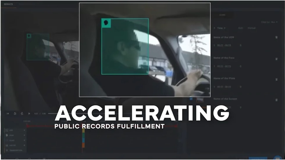
CHP to Accelerate Evidence Redaction & Public Records Fulfillment Through Veritone Redact
With Veritone Redact, the California Highway Patrol can redact video, audio, and image-based evidence, reducing time spent on evidence preparation and public record requests.
Read More →
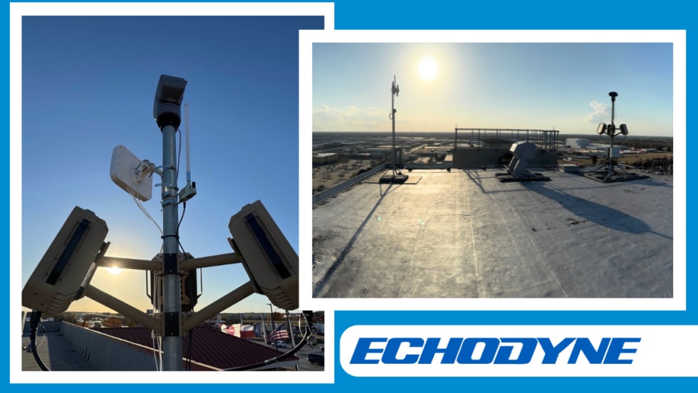
Echodyne Expands Public Safety Radar Applications Through Partnership with Axon
Echodyne has partnered with Axon to support safer and more scalable drone operations across law enforcement, homeland security, and Drone as First Responder programs globally.
Read More →
Miami Police Department Deploys Airwayz’s Overwatch Platform During FIFA World Cup Events
The deployment of Airwayz’s Overwatch airspace management platform during the FIFA World Cup demonstrates the future of airspace infrastructure for managing, securing, and coordinating complex urban airspace environments.
Read More →
How Patrolfinder Uses Data to Make Streets Safer
Law enforcement agencies have long relied on instinct and routine to optimize patrols. Patrolfinder uses data to help agencies see where officers go — and where they don’t — to improve visibility and maximize coverage.
Read More →
Crime Prevention by Merging Tech with Human Intervention
Elite Interactive Solutions tackles crime prevention with technology and human intervention, working closely with local police to provide insights when a response is needed. The key is to blend the latest in remote video monitoring, artificial intelligence, and a well-trained agent with eyes on the scene.
Read More →
Case Study Details Integration of Body-Worn Cameras with CAD
The Billerica Police Department (Massachusetts) improved transparency and accountability, sharpened evidence management, and reduced manual hours by integrating Axis Communications body-worn cameras with its Computer-Aided Dispatch (CAD) system.
Read More →
ZeroEyes Public Safety Alerts Integrates Samdesk for Real-Time Risk Detection and Awareness
ZeroEyes has integrated Samdesk into its Public Safety Alerts platform to deliver faster, verified intelligence to help organizations understand emerging risks and respond quickly.
Read More →
NJ Police Department Combines Strong Technology & Public Safety Strategy
The Fort Lee Police Department in New Jersey has modernized with Genetec Security Center, including video management, automatic license plate recognition (ALPR), and Clearance digital evidence management.
Read More →