

Super Bowl 50 Host Assisted by GPS Logic Mobile Data Systems
As preparations for hosting Super Bowl 50 got underway, Santa Clara County, CA, turned to GPS Logic Mobile Data Systems to assure a network of emergency vehicles with automated vehicle location, data capture and exchange technologies.
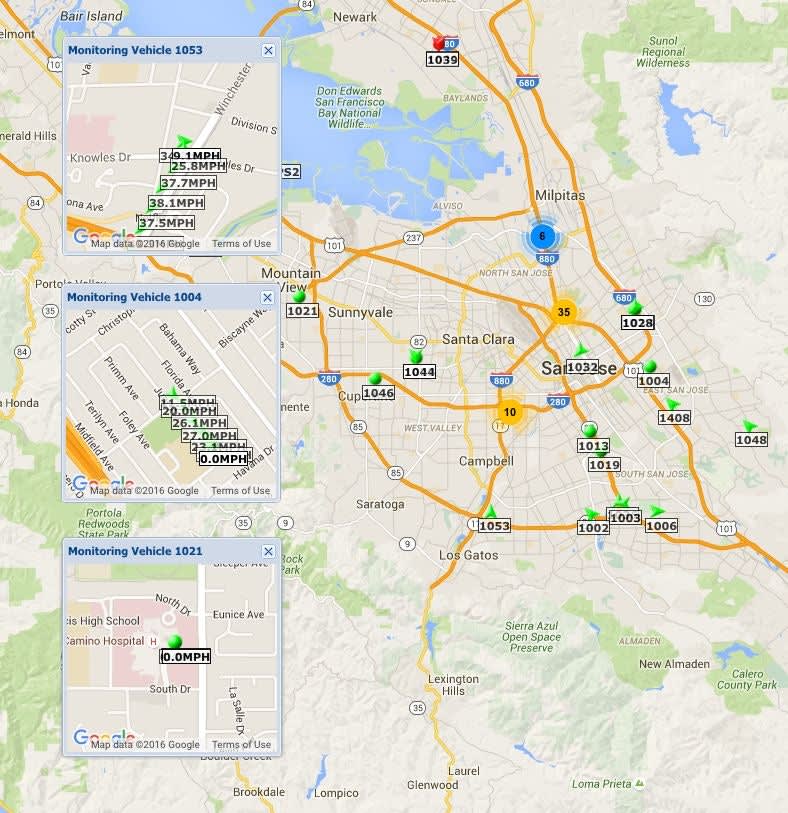

As preparations for hosting Super Bowl 50 got underway, Santa Clara County, CA, needed to be assured it could rapidly deploy Emergency Medical Services (EMS) vehicles in case of any emergency. That's why officials turned to Laguna Hills, CA-based technology company, GPS Logic Mobile Data Systems, to assure a network of emergency vehicles with automated vehicle location, data capture and exchange technologies.
Providing a way to quickly and securely exchange emergency medical information during the largest sporting event in the nation required the ability to instantly identify, transmit key data and deploy the closest appropriately equipped EMS vehicles to the scene of an emergency.
Working closely with the County's Common Regional Operating Picture (CROP) technology group and participating EMS agencies, GPS Logic's technical team quickly developed software interface capabilities specifically for Santa Clara County. The software allowed Santa Clara to instantly access key data of emergency medical vehicles through GPS Logic's proprietary cloud service in real time. With GPS Logic's advanced telematics national service, the data exchange and collection capabilities extended far beyond the county borders.
After the September 11 attacks, there has been a nationwide effort to link data, exchange information, and share communication platforms among law enforcement, emergency medical, and other first responder agencies. The GPS Logic technology supported the Super Bowl 50 technical initiative as the result of its ongoing telematics, M2M, and Internet of Things development since 2008. This advance technology provides essential, uninterrupted Automated Vehicle Location and data exchange among thousands of mobile Public Safety units and connected agencies -- a critical necessity during normal emergency services and a catastrophic event.
"We are pleased to offer this capability and support to our customers, while helping Santa Clara County in its Super Bowl and CROP initiative," said Ronald Cedillos, CEO of GPS Logic Mobile Data Systems. "The future of emergency medical services and Public Safety will rely on accurate, real time shared data. Our systems are uniquely positioned to be the key component of that data exchange."
About GPS Logic Mobile Data Systems
GPS Logic is a leading national provider of cloud-based mobile data communication technologies, M2M, and fleet location management systems. GPS Logic's systems are deployed in the largest Emergency Medical Services, law enforcement, fire departments, and other public safety agencies in the nation in addition to private entities. GPS Logic is headquartered in Orange County, CA, with a development office on the East Coast.
More Technology

2026 Vision FirstNet Users Summit to Explore How FirstNet Fusion and LMR Are Redefining Mission-Critical Communications
One of the sessions at the 2026 Vision FirstNet Users Summit will highlight hybrid devices bridging broadband and LMR. “Bridging Broadband and LMR: FirstNet Fusion and the Rise of Hybrid Devices” will explore how public safety agencies can modernize their communications environments while maintaining the reliability of land mobile radio.
Read More →
Cellebrite Expands Exclusive SkySafe Partnership to Deliver Immediate Drone Detection and Airspace Intelligence for Digital Investigations at Scale
By integrating SkySafe's drone detection and airspace intelligence with Cellebrite's platform, agencies can connect real-time and historical UAV flight data with mobile forensic evidence, all in one place.
Read More →
New DroneShield Report Reveals Serious Gaps in Airport, Critical Infrastructure Counter-Drone Security
Survey results, as part of “Airspace Under Pressure: A Global Assessment of Counter-UAS Readiness Across Airports and Critical Infrastructure,” indicate that 60% of organizations say they lack legal authority to act against unauthorized drones.
Read More →
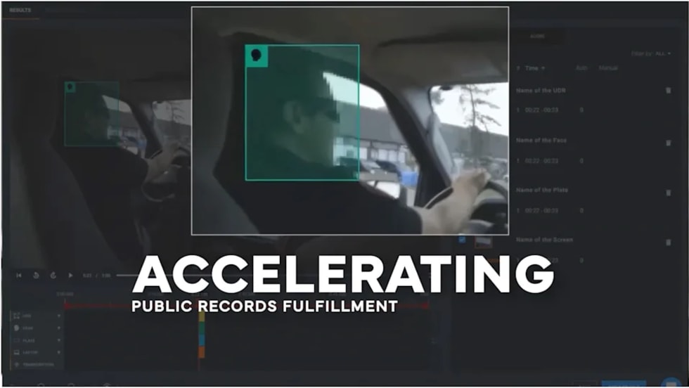
CHP to Accelerate Evidence Redaction & Public Records Fulfillment Through Veritone Redact
With Veritone Redact, the California Highway Patrol can redact video, audio, and image-based evidence, reducing time spent on evidence preparation and public record requests.
Read More →
Echodyne Expands Public Safety Radar Applications Through Partnership with Axon
Echodyne has partnered with Axon to support safer and more scalable drone operations across law enforcement, homeland security, and Drone as First Responder programs globally.
Read More →
Miami Police Department Deploys Airwayz’s Overwatch Platform During FIFA World Cup Events
The deployment of Airwayz’s Overwatch airspace management platform during the FIFA World Cup demonstrates the future of airspace infrastructure for managing, securing, and coordinating complex urban airspace environments.
Read More →
How Patrolfinder Uses Data to Make Streets Safer
Law enforcement agencies have long relied on instinct and routine to optimize patrols. Patrolfinder uses data to help agencies see where officers go — and where they don’t — to improve visibility and maximize coverage.
Read More →
Crime Prevention by Merging Tech with Human Intervention
Elite Interactive Solutions tackles crime prevention with technology and human intervention, working closely with local police to provide insights when a response is needed. The key is to blend the latest in remote video monitoring, artificial intelligence, and a well-trained agent with eyes on the scene.
Read More →
Case Study Details Integration of Body-Worn Cameras with CAD
The Billerica Police Department (Massachusetts) improved transparency and accountability, sharpened evidence management, and reduced manual hours by integrating Axis Communications body-worn cameras with its Computer-Aided Dispatch (CAD) system.
Read More →
ZeroEyes Public Safety Alerts Integrates Samdesk for Real-Time Risk Detection and Awareness
ZeroEyes has integrated Samdesk into its Public Safety Alerts platform to deliver faster, verified intelligence to help organizations understand emerging risks and respond quickly.
Read More →