

Connecting the Dots
Computers have revolutionized the art of crime mapping. Once just an exercise of sticking pins into a map glued to a bulletin board, crime mapping is now built on a foundation of “geographic information systems,” or GIS, a fancy term for creating, updating, and analyzing computerized maps.
Using crime-mapping technology, police intelligence officers and crime analysts can spot trends such as a rash of car thefts and allocate police resources to end the problem.
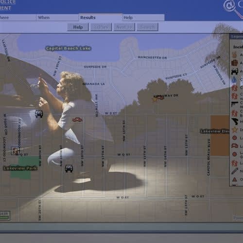
Imagine this scenario. A woman has been raped and murdered in her apartment sometime in the last six hours. You arrive at the scene as the lead investigator.
But instead of inspecting the crime scene, interviewing witnesses, and canvassing suspects, you log in to your department’s intranet and retrieve a 3D model of the building that clearly identifies each dwelling. Then you zoom in on the victim’s apartment, calling up a detailed floor plan.
A few keystrokes later, you cross-reference her apartment with a database of probationers and parolees whose movements have been tracked over the last day by the Global Positioning System (GPS) of satellites 11,000 feet above the earth. An “icon” that looks like a generic male character in a video game appears on screen in the living room, where the victim was found. You hover your mouse over the man and a window pops up with the name of a parolee and the times he entered and left the premises. Sure enough, he was there five hours ago. Clicking on his icon calls up his mug shots and criminal history.
Suspect identified, you launch an animated simulation within your 3D model that shows his movements, starting a few minutes before he left the apartment. You watch as his icon runs out of the apartment and down the stairs. The lobby’s closed-circuit monitor caught the real man on camera, so now your simulation switches seamlessly to a few seconds of actual video of him fleeing toward the exit. You freeze a frame and amplify it in high resolution until blood splatters are clear on his clothes.
Finally, you pinpoint the suspect’s current location. His icon appears overlaid on the ground floor of an abandoned warehouse three blocks away, and, within minutes, you’re there to question him.
That scenario may sound like science fiction, but you may be surprised how much of it is possible today using crime-mapping technology that is now on duty with American law enforcement agencies.
Beyond Stick Pins
Computers have revolutionized the art of crime mapping. Once just an exercise of sticking pins into a map glued to a bulletin board, crime mapping is now built on a foundation of “geographic information systems,” or GIS, a fancy term for creating, updating, and analyzing computerized maps. The relevance of GIS to law enforcement is that these maps can be easily overlaid with strategic and tactical information such as recent burglaries and rapes, addresses of sex offenders, and current deployments of manpower.
Crime mapping grabbed the public’s attention when the New York Police Department launched its COMPSTAT initiative under former Mayor Rudy Giuliani and former Police Commissioner William Bratton. COMPSTAT wasn’t the first use of GIS to fight crime, but it was the most high profile and much of the historic drop in crime in the Giuliani years was credited to COMPSTAT and its integration with what Bratton has called the core needs of all police organizations: timely and accurate intelligence, rapid response, effective tactics, and “relentless follow-up.”
It’s been nearly a decade since the NYPD adopted COMPSTAT, and crime mapping has emerged as a key crime-fighting tool across the nation. The following is a look at how this technology is serving law enforcement in many different communities.
Intel in the Trenches
The city of Lincoln, Neb., began developing a computerized mapping system in 1990, and its police department has embraced the technology. The Lincoln Police Department believes the primary value of GIS is to provide timely information to field personnel to help them plan their work and empower their crime-fighting efforts. “They know the local places and are out there mixing it up with the victims, offenders, convenience store clerks, cab drivers, and street kids,” says Lincoln PD Chief Tom Casady, who adds that marrying that expertise with technology gives his troops a formidable one-two punch.
The Lincoln PD had started a computerized record-keeping system as far back as 1980, and over the years had amassed volumes of data. The challenge was to mold the information into a practical tool for crime analysis. “GIS brings this data alive in a way that can’t be matched by a thick stack of green-striped paper,” says Casady.
Like the NYPD, the Lincoln PD holds regular meetings to interpret crime data and strategize responses. Lincoln’s version of COMPSTAT is called ACUDAT (Analyzing Crime Using Data About Trends). The sessions are designed to share information among sergeants, officers, detectives, and investigators.
While commanding officers may attend ACUDAT sessions, the priority is getting valuable intelligence to the street. For front-line Lincoln cops, whose tactical effectiveness often depends on focusing on one incident at a time, ACUDAT can be a real eye-opener, as it can map out for them in full color the connections hidden among the 400 or more incidents the department handles daily.
“[The officer] is the one who needs to know that the offense he or she just worked is related to several other reports,” says Casady, who explains that ACUDAT vividly depicts such relations. For example, adjacent icons representing two sex crimes on an ACUDAT map helped officers link a suspect in an indecent exposure case to a sexual assault on a child that occurred nearby.
The ACUDAT meetings are only one facet of the Lincoln PD’s aggressive approach to GIS. Fully enabled GIS workstations are also available to all officers and city employees, and they can even access the system at home through the department’s intranet. “If you can book your airline tickets online, you can use our GIS,” says Casady. “The learning curve is zero for anyone who’s used the Internet.” The LPD is also testing GIS on its mobile data computers. These initiatives have made Lincoln PD’s field personnel less reliant on the department’s crime analysis unit. Officers can now generate their own up-to-date crime maps without having to wait for one to be produced for them. “The ability to locate similar offenses quickly at any time of day or night can be quite valuable in leveraging a single case into a multiple clearance,” says Casady, noting that his officers have used GIS maps created on the fly to clear additional cases during suspect interviews.[PAGEBREAK]
Charting Crime’s Migration
Richard Lemmon is the crime analyst for Henry County, Ga., a suburb of Atlanta and the third-fastest growing county in the nation. He maintains multilayered maps of the jurisdiction’s precincts, districts, and crime categories, as well as the dates, times, and addresses of specific incidents. In addition, Lemmon retrieves incident reports filed by patrol officers and inputs them into his GIS, which “geocodes” the data, converting the crimes and their locations into graphics that can be overlaid on a map.
Lemmon says he looks for specific patterns and distributes the maps to precincts over the county’s intranet. “This is near real-time crime mapping. I can plot criminal activity as it is occurring, show how it is developing, how it is moving across the county boundaries,” he says.
“If an individual is breaking into vehicles or if there is a series of burglaries, we can see the cluster start and actually watch it migrate into other areas,” Lemmon adds. “From each event, we can collect pieces of information, including date, time, location, and add these to the MO used.”
The maps created by Lemmon help Henry County law enforcement determine whether they’re dealing with one or more perpetrators and where to allocate manpower to catch or at least deter offenders working in a particular area. “Since we can see crime patterns developing, our response times are now much faster than they were before we had this capability.”
Henry County’s population has jumped from 58,741 in 1990 to more than 119,000 today. And along with the boom in residents, the county has seen a proliferation of new roads, housing, and community institutions like schools and firehouses. Naturally the police have to stay on top of these changes. The county provides Lemmon with monthly updates that he inputs into his GIS, ensuring that his maps are current.
Eye in the Sky
In 2002 the Seminole County (Fla.) Sheriff’s Office hired the Veridian Corp. to track individuals on pre-trial release with its “VeriTracks” GPS program and compare their movements with the county’s crime incident reports.
At first glance, this is nothing new. Law enforcement has used electronic monitoring for years. And many agencies still use the conventional monitoring system that requires a radio transmitter built into an ankle bracelet to confirm that a detainee is within his home or other pre-authorized area.
GPS systems work pretty much the same way. For example, GPS-monitored detainees wear an ankle bracelet; however, now they can be tracked just about anywhere on the earth’s surface. Although GPS is not yet as accurate as the example given in this article’s opening scenario—for instance, it only works outdoors—it’s clearly arrived as a crime-fighting tool.
Seminole County is one of the first jurisdictions to combine GPS monitoring with crime mapping. “Today, more than ever, it is critical that police and probation professionals have at their disposal tools to remove the anonymity that most individuals on supervision enjoy,” says Seminole County Sheriff Don Eslinger. “This system reminds them that we will know if they are committing new crimes, and we will not tolerate their criminal activity.”
VeriTracks monitors an individual’s movements throughout the day then plots his or her locations on computer maps of crimes in the last 24 hours. The sheriff’s office can access the system directly. It also receives automatic e-mails when the system red-flags a defendant for being near a crime scene or entering a location that’s been declared off-limits to him, such as a suspected pedophile who’s been ordered to keep away from a school zone.
A growing number of police agencies also use GPS to better protect their officers and deploy them more efficiently. Both the Suffolk County (N.Y.) Police Department and the Hernando County (Fla.) Sheriff’s Office have implemented automatic vehicle location (AVL) systems that map the precise coordinates of each patrol car. Dispatchers can monitor real-time movements of their fleets, and deploy the closest units to an emergency or crime scene. And should an officer need backup, the dispatcher instantly knows where to send it. AVL also gives police managers a strategic tool by providing an overview of deployments so manpower can be evenly distributed or concentrated in hot spots.
Virtual Reality
The Duval County (Fla.), Sheriff’s Office recently teamed up with Harris Corp. to build a three-dimensional “virtual” model of Jacksonville Landing, a popular shopping and entertainment complex overlooking the St. John’s River in Jacksonville. The model provides an enormous amount of detail compared to a traditional paper map or even a computer-generated “flat” map. Deputies can view the complex from different angles and see its exits, windows, and other chokepoints. They can also retrieve floor plans for facilities within the complex. For law enforcement and other emergency workers responding to a crisis, this information could prove priceless.
Crime mapping has evolved from a statistical exercise into an intelligence tool that police can use to prevent crimes. And the technology and its application are gaining acceptance nationwide.
But the most important thing cops need to know about crime mapping is that it does not automate policing. The most sophisticated crime analysis data means little if it’s not acted upon by trained, responsible professionals. Consider the following computer-age cautionary tale. When convicted rapist Lawrence Napper was paroled in April 2000, he was placed in a GPS-monitoring program in Texas. The technology—ankle bracelet, receiver, computers, and of course those satellites circling the globe—did exactly what it was supposed to. It followed him and it logged his every move. Yet, over the course of nine months, Napper violated his parole more than 400 times by entering zones restricted to him, including schools and playgrounds. He even drove around Texas Southern University, the same place he’d once kidnapped and raped a student. And Texas officials did nothing. Consequently, in February 2001 Napper abducted and sexually assaulted a six-year-old boy.
This tragedy could have easily been prevented had trained law enforcement personnel been monitoring Napper’s movements and reported his parole violation to officers in the field. The message here is simple: All the crime-mapping technology in the world is useless if no one acts on the intel that it provides.
More Technology

Pimloc Launches Secure File Sharing to Streamline Release of Redacted Video
Pimloc’s Secure File Sharing lets organizations deliver redacted video, audio, and documents through expiring, passcode-protected links, accelerating delivery while reducing security, compliance, and chain-of-custody risks.
Read More →
2026 Vision FirstNet Users Summit to Explore How FirstNet Fusion and LMR Are Redefining Mission-Critical Communications
One of the sessions at the 2026 Vision FirstNet Users Summit will highlight hybrid devices bridging broadband and LMR. “Bridging Broadband and LMR: FirstNet Fusion and the Rise of Hybrid Devices” will explore how public safety agencies can modernize their communications environments while maintaining the reliability of land mobile radio.
Read More →
Cellebrite Expands Exclusive SkySafe Partnership to Deliver Immediate Drone Detection and Airspace Intelligence for Digital Investigations at Scale
By integrating SkySafe's drone detection and airspace intelligence with Cellebrite's platform, agencies can connect real-time and historical UAV flight data with mobile forensic evidence, all in one place.
Read More →

New DroneShield Report Reveals Serious Gaps in Airport, Critical Infrastructure Counter-Drone Security
Survey results, as part of “Airspace Under Pressure: A Global Assessment of Counter-UAS Readiness Across Airports and Critical Infrastructure,” indicate that 60% of organizations say they lack legal authority to act against unauthorized drones.
Read More →
CHP to Accelerate Evidence Redaction & Public Records Fulfillment Through Veritone Redact
With Veritone Redact, the California Highway Patrol can redact video, audio, and image-based evidence, reducing time spent on evidence preparation and public record requests.
Read More →
Echodyne Expands Public Safety Radar Applications Through Partnership with Axon
Echodyne has partnered with Axon to support safer and more scalable drone operations across law enforcement, homeland security, and Drone as First Responder programs globally.
Read More →
Miami Police Department Deploys Airwayz’s Overwatch Platform During FIFA World Cup Events
The deployment of Airwayz’s Overwatch airspace management platform during the FIFA World Cup demonstrates the future of airspace infrastructure for managing, securing, and coordinating complex urban airspace environments.
Read More →
How Patrolfinder Uses Data to Make Streets Safer
Law enforcement agencies have long relied on instinct and routine to optimize patrols. Patrolfinder uses data to help agencies see where officers go — and where they don’t — to improve visibility and maximize coverage.
Read More →
Crime Prevention by Merging Tech with Human Intervention
Elite Interactive Solutions tackles crime prevention with technology and human intervention, working closely with local police to provide insights when a response is needed. The key is to blend the latest in remote video monitoring, artificial intelligence, and a well-trained agent with eyes on the scene.
Read More →
Case Study Details Integration of Body-Worn Cameras with CAD
The Billerica Police Department (Massachusetts) improved transparency and accountability, sharpened evidence management, and reduced manual hours by integrating Axis Communications body-worn cameras with its Computer-Aided Dispatch (CAD) system.
Read More →