

Critical Incident Intel
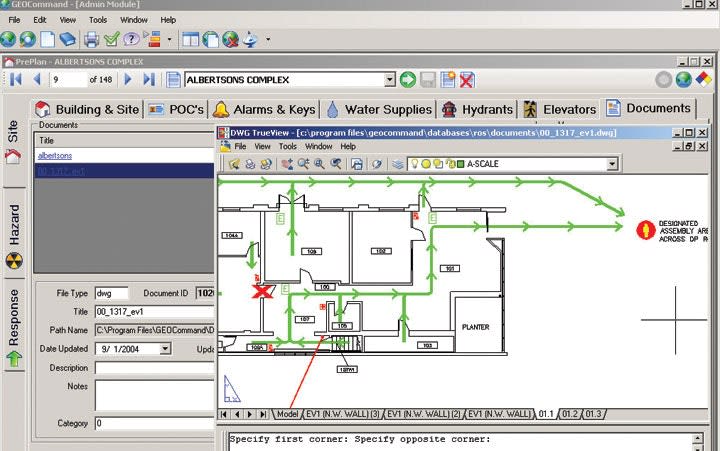
Fortunately, a company called GEOCommand has created a software program that can supply you with vital information on key buildings in your jurisdiction, including floorplans and the presence of wicked little surprises like hazardous materials.

It's the call that every patrol supervisor dreads. Dispatch has sent you a "shots fired" call. People are down. You have an active shooter on your hands.
The location is an industrial plant. You don't know exactly what they do there, but you know that they use some nasty toxic stuff to do it. And now you and your officers have to enter this place and engage an unstable gunman.
Right now, you would sell your right arm for a floorplan and some information about what exactly is in use in the building. After all, you don't want to order your people into a hazardous material zone without the proper protection.
Fortunately, you don't have to sell your right arm. A company called GEOCommand has created a software program that can supply you with vital information on key buildings in your jurisdiction, including floorplans and the presence of wicked little surprises like hazardous materials.
GEOCommand is essentially a geographic information system (GIS) tool that was designed to give first responders valuable intel about any location in their area of operation. In the active shooter scenario above, if the patrol supervisor had GEOCommand on his mobile computer, then he would have access to floorplans, elevator and power supply locations, hazardous material inventories with safety instructions, information on the nearest hospitals, and other critical intel. He could also relay this information to any number of responding units.
Michael Rand, marketing director for GEOCommand, says the product was developed as a resource for firefighters working at federal laboratories, and it has grown into a tool for all first responders. "We see GEOCommand as an excellent resource for SWAT and other law enforcement operations," he says.
GEOCommand can be integrated with your existing computer-aided dispatch system. This means that incident commanders can use it not only to gain valuable intel on the building that their officers must operate in, but also to allocate resources to respond to that incident.
One of the best features of GEOCommand is that it allows local officers to create their own building pre-plans. For example, with the growing concerns over campus active shooters and terrorist attacks on schools and universities, an agency could use GEOCommand to create detailed profiles on all campus buildings in its jurisdiction and relay that information to responders over their mobile computers as they speed toward an incident. Such intel could save time and lives.
"You don't have to be a GIS specialist to add your own preplans in GEOCommand," says Rand. "It's easy to use and all of the capability that you need is built into the product." Need FREEInfo? Use #22301.
More Technology

Safariland Solis Rethinks Concealable Duty
What if Level I retention didn’t require a full duty rig? Safariland’s Solis delivers trusted ALS security in a streamlined OWB platform built for administrative and plainclothes professionals who need protection without the bulk.
Read More →
How Patrolfinder Uses Data to Make Streets Safer
Law enforcement agencies have long relied on instinct and routine to optimize patrols. Patrolfinder uses data to help agencies see where officers go — and where they don’t — to improve visibility and maximize coverage.
Read More →
Crime Prevention by Merging Tech with Human Intervention
Elite Interactive Solutions tackles crime prevention with technology and human intervention, working closely with local police to provide insights when a response is needed. The key is to blend the latest in remote video monitoring, artificial intelligence, and a well-trained agent with eyes on the scene.
Read More →


Case Study Details Integration of Body-Worn Cameras with CAD
The Billerica Police Department (Massachusetts) improved transparency and accountability, sharpened evidence management, and reduced manual hours by integrating Axis Communications body-worn cameras with its Computer-Aided Dispatch (CAD) system.
Read More →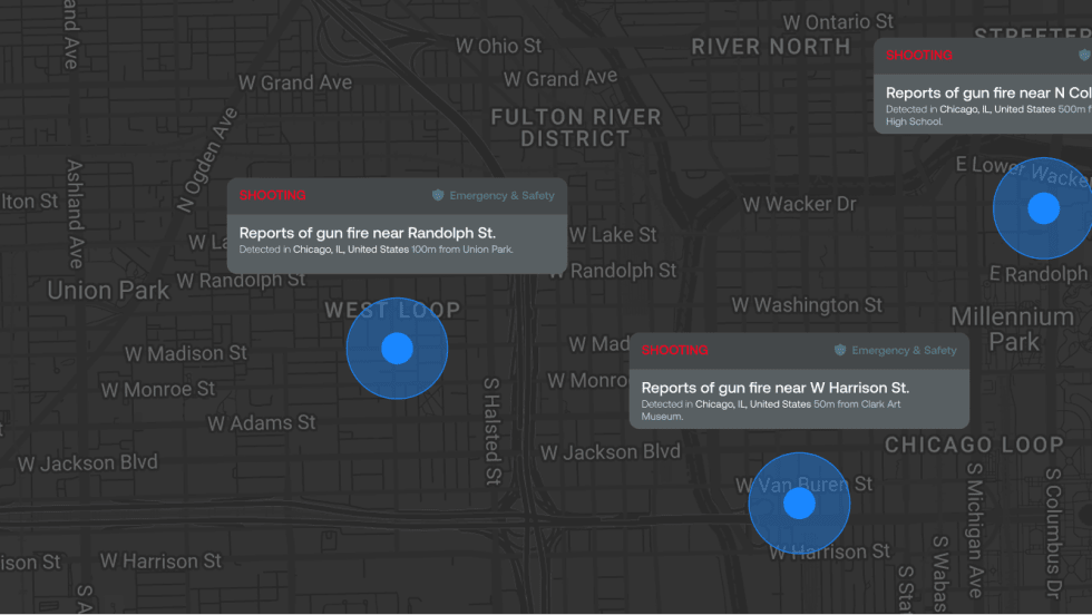
ZeroEyes Public Safety Alerts Integrates Samdesk for Real-Time Risk Detection and Awareness
ZeroEyes has integrated Samdesk into its Public Safety Alerts platform to deliver faster, verified intelligence to help organizations understand emerging risks and respond quickly.
Read More →
NJ Police Department Combines Strong Technology & Public Safety Strategy
The Fort Lee Police Department in New Jersey has modernized with Genetec Security Center, including video management, automatic license plate recognition (ALPR), and Clearance digital evidence management.
Read More →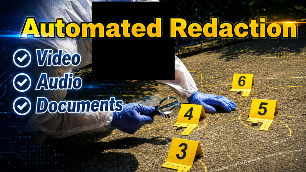
Pimloc & Dynamic Workflow Solutions Partner to Deliver Data Management and Automated Redaction
The joint redaction solution from Pimloc and Dynamic Workflow Solutions helps agencies reduce FOIA response time and compliance risk by automatically redacting faces, license plates, and other sensitive information from digital evidence.
Read More →
The University of Alabama Rolls Out Couter-Drone Technology
The University of Alabama is using D-Fend Solutions as a counter-drone technology supplier for campus and game-day airspace security. The University integrates D-Fend’s EnforceAir into its Emergency Operations Center (EOC), utilizing a unified command framework to collaborate with local, state, and federal partners during major events.
Read More →
Motorola Solutions Now Part of the Cyber Threat Alliance
Motorola Solutions is now part of the Cyber Threat Alliance, the first formally organized nonprofit group of cybersecurity practitioners that work together in good faith to share threat information and improve global defenses against advanced cyber adversaries.
Read More →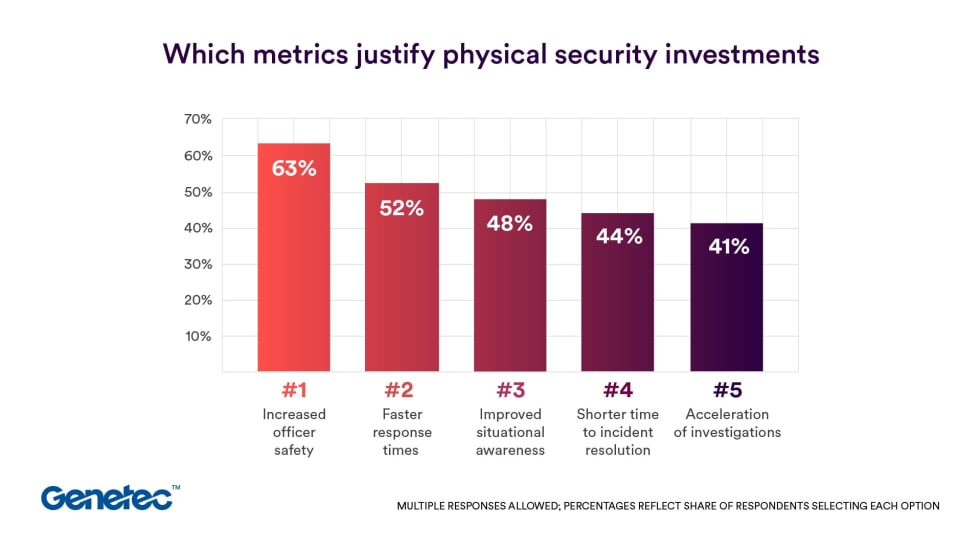
Genetec 2026 State of Physical Security Report Reveals Public Safety Priorities & Challenges
Survey results from Genetec’s 2026 State of Physical Security Report highlight the demand for integrated systems that improve response times and reduce investigative workload. Nearly nine in 10 respondents said they use security data to help keep officers safe.
Read More →