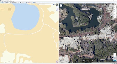
 Versaterm Public Safety now can provide dispatchers and first responders with aerial imagery to improve team coordination and situational awareness.Versaterm
Versaterm Public Safety, a global public safety solutions provider, and EagleView Technologies have expanded their partnership to provide EagleView’s orthogonal and oblique imagery within Versaterm's Computer-Aided Dispatch (CAD) and mobility (MDT) systems.
"Our partnership with EagleView continues to evolve in ways that benefit the public safety agencies and the communities they serve," said Sue Langlois, CEO of Versaterm Public Safety. "This integration is more than just a technical upgrade; it's the next step in our mission to empower better, faster, and safer responses.”
EagleView’s geospatial data and imagery library encompasses 94% of the U.S. population and its technology portfolio comprises more than 300 patents.
Versaterm said with this expanded integration, first responders and dispatch centers can rapidly access EagleView's high-resolution orthogonal and oblique imagery, offering top-down and side angles of residential and commercial buildings, roads, and other critical areas directly within Versaterm's CAD and MDT system workflows.
These enhanced views, according to Versaterm, offer improved situational awareness with a clearer understanding of scale – i.e., distinguishing between a one-story and a 50-story structure – and provide insights into topography and sightlines.
